Fun run of days ahead
Eastern Tasmania Surf Forecast by Craig Brokensha (issued Wednesday 28th November)
Best Days: Thursday morning, Friday morning, Saturday morning, Sunday, early Monday morning
Recap
Great waves yesterday with a fun reinforcing E/SE swell and morning offshore before winds shifted more S'ly.
Today there was still swell in the mix but winds were less than ideal and protected spots were the only option.
Today’s Forecaster Notes are brought to you by Rip Curl
This week and weekend (Nov 29 – Dec 2)
We should still see some fun sets out of the E/SE tomorrow with cleaner conditions under a light variable wind.
Open beaches should still see 3ft sets, easing through the day and down further from a smaller 2ft Friday. An E/NE sea breeze will be seen tomorrow, with W/NW tending N'ly winds on Friday.
 Our new E/NE swell for the weekend is still on track, with a deepening low currently bringing torrential rain and strong winds to the southern NSW coast.
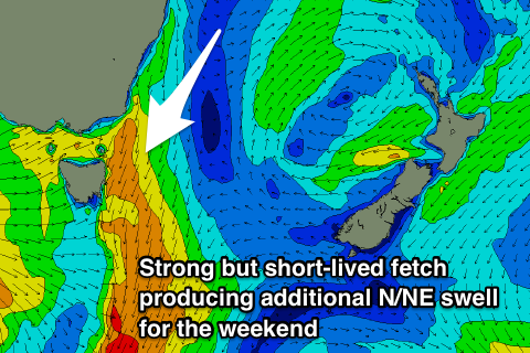
The low will drift east-southeast while broadening, with a fetch of strong E/NE winds being aimed towards us from tomorrow morning through Friday, and even Saturday but smaller in scope.
This will produced a prolonged E/NE swell event, building Saturday and reaching 2-3ft through the day, holding Sunday before easing from 2ft Monday morning.
Also in the mix on Sunday will be a short-lived and localised N/NE windswell event as strong N/NE winds develop right off our coast Saturday evening and early Sunday morning.
This will kick up a rapid increase in N/NE swell, peaking Sunday morning to 3ft+ across north-east swell magnets, but easing just as quick with a gusty W/SW change.
Come Monday fresh to strong W/NW winds will continue with the smaller easing E/NE swell.
Longer term there's nothing too significant on the cards for our region besides small levels of refracted S'ly swell, so make the most of the days of waves.

