Refracted south swell followed by peaky east swell
Eastern Tasmania Surf Forecast by Craig Brokensha (issued Monday 1st October)
Best Days: Early Wednesday south magnets, Friday morning south magnets, Saturday and Sunday mornings
Recap
Hardly a hint of flukey S'ly swell over the weekend and today, which isn't totally unexpected.
Today’s Forecaster Notes are brought to you by Rip Curl
This week and weekend (Oct 2 – 7)
Tomorrow will more than likely remain tiny to flat as we fall in between swell pulses, but we should see a bit more size through Wednesday ahead of a stronger groundswell Thursday/Friday.
Wednesday's swell will be generated by a great polar fetch of severe-gale W'ly winds that are currently south-west of the state and will pass south of us this evening.
 The groundswell is due to peak Wednesday morning to 2-3ft across south swell magnets with an early light offshore W'ly, giving into a gusty S/SE change through the day as a surface trough slips across the state.
A small NE windswell signal should also be seen to 1-2ft from a burst of NE winds forming down the southern NSW coast.
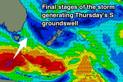
Moving into Thursday and we'll see a strong long-period S'ly groundswell pushing up and around the corner of the state, generated by a significant low that's currently south-west of WA.
This low will produce a pre-frontal severe-gale W/NW fetch that won't be ideally in our swell window, followed by a much better severe-gale W/SW fetch south-west and south of the state, on the edge of our southern swell window.
This will be where we'll see our size generated from, with the groundswell due to arrive through Thursday and provide good 3-4ft sets across south swell magnets.
 Winds will unfortunately remain poor, especially for south swell magnets and out of the S/SE as the trough forms into a low off the southern NSW coast, stalling to our north-east through the end of the week, drifting south-east through the weekend.
This is expected to produce an additional E'ly swell to the mix as the S'ly swell fades, with easing sets from the 3ft+ range at south magnets Friday, better Saturday and Sunday with sets to 3ft out of the east.
Winds should be better and W/SW on Friday morning before E/NE sea breezes kick in, similar Saturday.
Longer term there are a few different swell sources from the S'th and E but we'll have a closer look at this on Wednesday.

