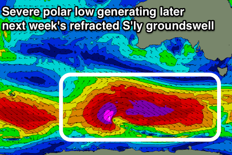
Refracted southerly swells, largest later next week
Eastern Tasmania Surf Forecast by Craig Brokensha (issued Friday 28th September)
Best Days: No great days with flukey south swell pulses and onshore when biggest
Recap
Good clean easing levels of S'ly groundswell yesterday from 3-4ft at south magnets, while this mornig there was hardly anything left at all.
Today’s Forecaster Notes are brought to you by Rip Curl
This weekend and next week (Sep 29 – Oct 5)
The coming forecast period will consist of flukey and refracted levels of S'ly groundswell from strong polar frontal systems pushing along the polar shelf.
Over the weekend a very flukey and small S'ly swell may be seen later tomorrow, generated by a weak front moving in from the west under the country the last couple of days.
 On the tail on this front a fetch of W/SW winds were generated in our swell window, with a possible small 2ft wave seen later Saturday fading from 1-2ft Sunday.
Into Sunday afternoon and more so Monday more tricky S'ly swell is due, spreading up radially from fetches of pre-frontal W/NW gales which aren't favourably aligned at all.
In saying this the strength and longevity of these fetches may produce a small 2ft wave on the south magnets later Sunday and all of Monday before fading Tuesday.
Winds look generally favourable for south magnets through this period and out of the north-western quadrant ahead of a SE change on Tuesday.
The best looking of all these storms is expected to developing south of WA early next week, with a significant and elongated fetch of severe-gale W/NW and then W/SW winds due to move through our swell window along the polar shelf.
A better S'ly groundswell should be seen off this low, arriving overnight Wednesday and peaking Thursday.
Size wise we're looking at inconsistent sets to 3-4ft through the day, but a weak trough moving up the coast may bring poor S/SE winds, spoiling the swell. Therefore check back Monday for an update on this as this is the most surfable swell of them all.

