Make the most of Thursday, better swell late next week
Eastern Tasmania Surf Forecast by Craig Brokensha (issued Wednesday 26th September)
Best Days: Thursday across south swell magnets
Recap
A fun S/SE swell yesterday to 2-3ft, while today our new S'ly groundswell was filling in, 2-3ft again this morning but we should have seen more size during the day across south magnets up to 3-5ft.
Today’s Forecaster Notes are brought to you by Rip Curl
This week and weekend (Sep 27 – 30)
Today's pulse of S'ly groundswell is due to ease back slowly through tomorrow owing to the broad and slow moving nature of the vigorous polar frontal progression that generated it.
South swell magnets should see 3ft to possibly 4ft sets early tomorrow, dropping back through the day along with a small N/NE windswell in the mix.
 The windswell doesn't look to reach any major size, with the N/NE fetch off our coast not reaching any real strength of length to our north.
Sets to 2ft may be seen into the afternoon with the fading S swell and fresh N/NW winds favouring northern corners.
Friday looks small with a mix of easing swells from 2ft max but with a W/NW offshore.
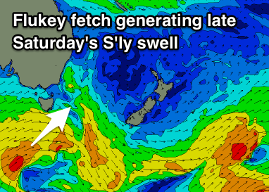
Into the weekend we're looking at tiny to flat surf, with a possible small pulse of S'ly swell later Saturday from a weak fetch of W/SW winds in our southern swell window.
We may see a small 1-2ft of S'ly swell across south magnets late in the day with W'ly winds, fading Sunday.
We're then looking at tiny refracted levels of S'ly groundswell through Monday and Tuesday next week from zonal W'ly fetches.
No size is expected with ebbs and pulses across south magnets to 1-2ft.
Longer term a severe and polar shelf hugging storm looks to generate a good long-period S'ly groundswell for late in the week, but more on this Friday.

