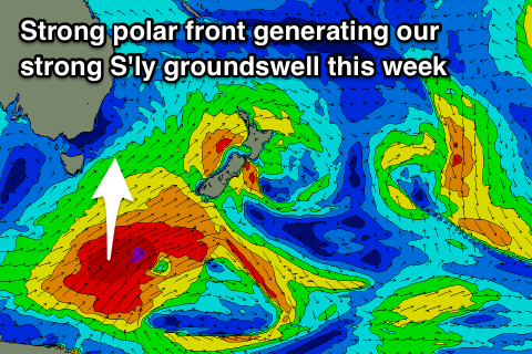
Good strong S'ly groundswell, slow thereafter
Eastern Tasmania Surf Forecast by Craig Brokensha (issued Monday 24th September)
Best Days: Wednesday and Thursday south magnets, Friday morning
Recap
It's hard to tell if Friday afternoon's south swell spiked across south magnets, but the reports from Saturday morning weren't too promising on the backside.
A new S'ly swell should of built later yesterday and provided some small fun waves this morning from a strong front pushing up and past us yesterday afternoon.
Today’s Forecaster Notes are brought to you by Rip Curl
This week and weekend (Sep 25 – 30)
A small hint of leftover S'ly swell should be seen tomorrow morning, but we've got a much better and cleaner pulse of S'ly groundswell due through the middle of the week.
There's been a slight downgrade in size with a strengthening polar frontal progression that's currently south of us pushing quicker east and towards New Zealand than ideal.
 Still we'll see a broad fetch of gale to severe-gale SW winds projecting north-east through our southern swell window, producing a moderate sized S'ly groundswell for Wednesday, coming in around 3-5ft across south swell magnets with a W/NW tending fresh NE breeze.
The easing trend should be slow owing to the broad and slow moving nature of the polar progression, with easing 3-4ft sets across south magnets Thursday morning with gusty N'ly tending NW breeze as a cold front pushes in from the west.
Some small N/NE windswell is due to be in the mix as well to 2ft+, fading with the change, clean Friday with a mix of swells to 2ft.
The outlook then remains a little slow until next week when we may see some small refracted pulses of S'ly swell but not to Wednesday's size. So make the most of it.

