Good N/NE swell to end the week
Eastern Tasmania Surf Forecast by Craig Brokensha (issued Monday 3rd September)
Best Days: South swell magnets dawn tomorrow, Thursday in northern corners, Friday
Recap
A fun clean 2-3ft of NE swell Saturday morning ahead of the One Night Stand, and then some new building S'ly swell on Sunday with morning offshores.
Today the south swell was still around and nice and clean, but a drop should have been seen through this afternoon with sea breezes.
Today’s Forecaster Notes are brought to you by Rip Curl
This week and weekend (Sep 4 – 9)
Our current S'ly swell should continue to ease through tomorrow, with small fading sets from 1-2ft at south swell magnets.
We then look at our N/NE windswell event through the middle to end of the week.
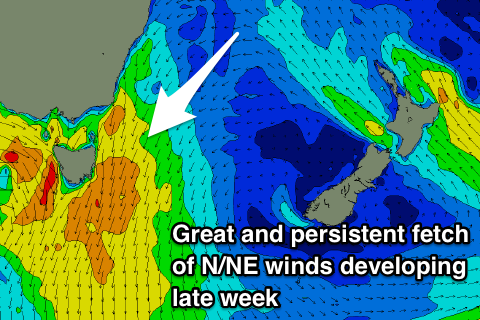
 As touched on last update, a strong mid-latitude frontal progression moving in from the west will squeeze a strong and stubborn high in the Tasman Sea.
We'll see a strengthening and broadening fetch of N/NE winds building down the southern NSW coast and off our region from Wednesday, strongest on Thursday ahead of an overnight W/NW change.
This will produce building levels of N/NE windswell through Wednesday afternoon along with strengthening N/NE winds, peaking on Thursday as strong N'ly winds persist until around dark.
We're looking at solid 4-6ft surf out of the N/NE developing on Thursday, clean and easing rapidly Friday due to the timing of the change on dark Thursday.
North-east magnets look to drop from 3-4ft, back to 2ft into the afternoon under W/NW breezes.
Longer term there isn't too much on the cards, therefore make the most of the swell later week.

