Fun southerly swell, followed by a good north-northeast swell
Eastern Tasmania Surf Forecast by Craig Brokensha (issued Friday 31st August)
Best Days: Dawn Saturday north-east swell magnets, Sunday protected spots, Monday south swell magnets, Friday
Recap
Pumping easing SE groundswell from the 5-6ft range yesterday morning, smaller into this morning with a new N/NE windswell becoming more dominant.
We should see the N/NE windswell hitting 3-4ft now, and a W/NW change looks to be a touch later and near dark this evening.
Today’s Forecaster Notes are brought to you by Rip Curl
This weekend and next week (Sep 1 – 7)
With the slight delay in the change due this evening and a good fetch of N/NE winds hanging in our swell window this afternoon off the far southern NSW coast, we're now due to see a touch more size left out of the NE at dawn tomorrow.
Magnets are due to see 2ft waves, if not for the odd sneaky bigger one, dropping rapidly through the day with a fresh W/SW tending SW wind.
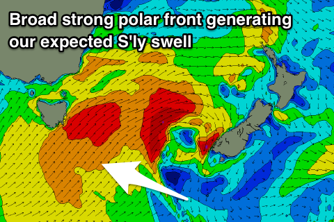
 As we move into Sunday a strong and broad cold front pushing up past the south-east corner of the state is due to project a fetch of strong to gale-force S/SW winds through our southern swell window.
This should produce a good increase in new S'ly swell for Sunday, likely biggest through the middle of the day.
We're looking at surf in the 4ft range across south facing beaches though with a W/SW-SW tending S/SW breeze. Not ideal.
Monday is looking cleaner with a light morning W'ly and easing S'ly swell from the 3ft+ range if we're lucky.
Tuesday looks small to tiny, but as touched on in the last update, we're due to see a solid N/NE windswell event developing later in the week.
A strong mid-latitude low is expected to move in from the west, squeezing a strong high in the Tasman Sea.
The high will slow the movement of the low and as a result a building and strengthening fetch of N/NE winds will develop through our north-eastern swell window from Wednesday evening through the end of the week.
Building and strengthening levels of N/NE swell are expected, likely biggest on Friday as a W/NW change moves through.
We'll have a closer look at this on Monday though. Have a great weekend!

