Very fleeting pulse of south swell
Eastern Tasmania Surf Forecast by Craig Brokensha (issued Friday 27th July)
Best Days: Sunday afternoon
Recap
A continuation of tiny to flat surf across the coast.
Today’s Forecaster Notes are brought to you by Rip Curl
This weekend and next week (Jul 28 – Aug 3)
Want to receive an email when these Forecaster Notes are updated? Then log in here and update your preferences.
There hasn't really been much of an improvement to our poor outlook, with the models showing a tiny kick in N/NE windswell on Sunday, but my take on this is it won't be surfable.
A very short-lived fetch of N/NE winds will be aimed through our swell window Sunday morning before quickly shifting away, with a possible spike in N/NE swell to 1ft+ as winds shift NW.
 This swell will fade into Monday but a more likely S'ly swell is due to fill in, generated as a mid-latitude low pushes across us.
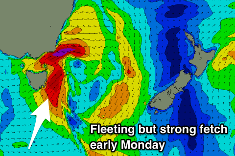
A very short-lived but stronger fetch of S/SW winds are due to be generated up our coast early Monday morning, before pushing away to the east through the day.
We may see a very small and fleeting pulse of S'ly swell to 2ft to maybe 3ft if all goes to plan across south magnets through the day, tiny elsewhere and with improving W/SW tending W/NW winds.
The swell will be gone by Tuesday with nothing significant due until possibly late in the week when a very strong mid-latitude front pushes across the country, directing strong to gale-force N/NE winds into us. More on this Monday. Have a great weekend!

