Fun easterly swell pulses from Sunday
Eastern Tasmania Surf Forecast by Craig Brokensha (issued Friday 13th July)
Best Days: Sunday, Monday, northern corners Tuesday
Recap
Small persistent levels of S'ly swell persisting across south magnets and open beaches, bigger than expected, though it's always tough coming in cold from holiday's.
Today’s Forecaster Notes are brought to you by Rip Curl
This weekend and next week (Jul 14 - 20)
Want to receive an email when these Forecaster Notes are updated? Then log in here and update your preferences.
Looking at the coming weekend and early next week, the structure of the low linked to our easterly swells has changed a little and there's been a slight downgrade in the expected size.
Firstly though tomorrow a new pulse of S'ly groundswell is due, produced by a strong though weakening polar low on the edge of our southern swell window through the week.
South magnets should continue at 3ft though winds will be an issue, SW at dawn but fresh from the S/SE thereafter as the low squeezes against out coast.
This squeezing will see a temporary fetch of strong S/SE-SE winds generated through our swell window tomorrow, reaching a peak in intensity through the late morning.
 A fun pulse of SE tending E/SE swell will be generated by this intensification, filling in Sunday and peaking later in the day/overnight. Open beaches should build a good 3-4ft by dark along with all day offshore W/NW winds.
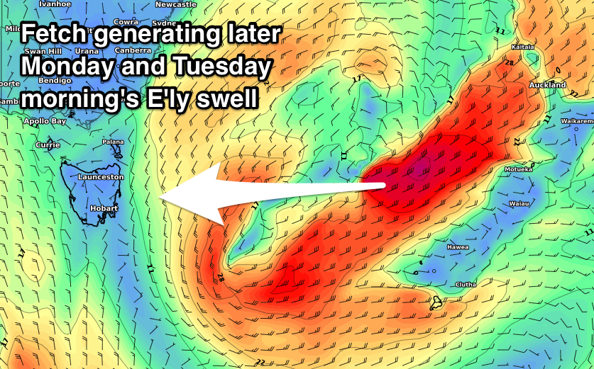
This swell will ease through Monday from a similar size, but an infeed of strong to gale-force E/NE winds on the eastern side of the low should produce some new reinforcing E'ly groundswell for the afternoon.
This fetch isn't great with it being slim and a little disjointed and as a result we're now only looking at sets to 3ft+ late in the day, easing rapidly from 3ft Tuesday morning.
Winds will remain offshore from the W/NW tending NW into Monday, strengthening from the N/NW on Tuesday with a vigorous approaching front, favouring northern corners.
The front will pass on Wednesday leaving gusty W'ly winds and fading 1ft to maybe 2ft sets, with that secondary possible low now looking to whisk off to quickly to the east to generate any swell late week.
We'll have another look at this and Tuesday's easing swell on Monday, and in the meantime have a great weekend!

