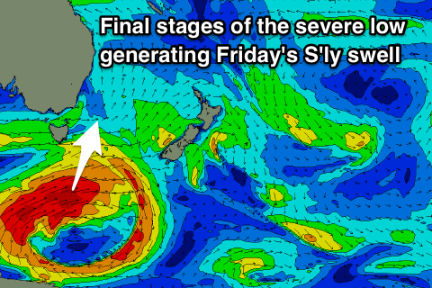
Strong S'ly groundswell Friday morning, further pulse Saturday afternoon
Eastern Tasmania Surf Forecast by Craig Brokensha (issued Wednesday 16th May)
Best Days: South magnets later tomorrow, Friday, Saturday afternoon and Sunday morning
Recap
Good clean fun easing E/SE swell from 3-4ft yesterday, smaller today with a new S'ly swell across south magnets.
Today’s Forecaster Notes are brought to you by Rip Curl
This week and weekend (May 17 – 20)
These notes are brief as Ben's away.
Any S'ly swell seen today will ease back through tomorrow from a small 2ft at south magnets.
 Very late in the day but more so Friday morning our large new S'ly groundswell should push into the coasts south magnets, generated by a severe low pushing along the polar shelf the last couple of days.
A great fetch of storm-force W'ly winds have been generated, with the low now weakening and projecting towards New Zealand through tomorrow.
A large long-period but acute S'ly swell has been generated, with a late kick to 3ft+ possible, coming in at 4-6ft Friday morning, easing through the day. It should be noted that with the acute angle, more open beaches and southern corners will be small to tiny.
Winds tomorrow will be offshore all day and from the W, with W'ly tending W/SW winds on Friday.
Saturday morning will start slow but a strong low pushing past us Friday night is expected to produce a new S'ly groundswell for Saturday afternoon to 3-4ft with W'ly winds, easing back into Sunday.
Moving into next week and we're looking at continued S'ly swell pulses as a strong node of the Long Wave Trough sits over the Tasman Sea, directing cold fronts up through our southern swell window.
We may see some larger energy through next week, but more on this Friday.

