Oversized SE swell tomorrow, easing through the weekend and clean Monday/Tuesday
Eastern Tasmania Surf Forecast by Craig Brokensha (issued Friday 11th May)
Best Days: Protected spots tomorrow and Sunday, Monday, Tuesday morning
Recap
Building S/SE swell yesterday with average winds with large stormy and victory at sea conditions today.
Today’s Forecaster Notes are brought to you by Rip Curl
This week and weekend (May 12 – 18)
These notes are brief as Ben's away.
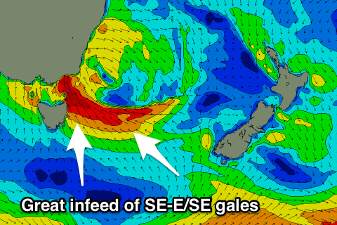
A severe low is currently sitting right off our coast and we'll see this system continuing to generate a fetch of S/SE-SE gales into us this evening, angling away through tomorrow morning and then slowly weakening through Sunday.
 With this we'll continue to see oversized SE swell energy tomorrow, easing back from the 10ft range along with strong to gale-force S-S/SW winds. There'll also be some large E/SE energy as the fetch of gales extend out east of is into the Tasman Sea.
This will open up a few options but only for experienced surfers.
Moving into Sunday we're looking much weaker and easing from 4-5ft with a less than favourable S-S/SE breeze.
Monday will be the cleanest and best at open beaches with easing levels of E/SE swell while later in the day a fresh pulse of E/SE swell from a good fetch of SE winds just passing through the edge of our eastern swell window Sunday is due.
Good 3-4ft sets are due Monday morning, easing a touch through the day, with 3ft+ waves Tuesday morning.
Winds look great and offshore Monday and Tuesday morning ahead of a strong S'ly change. More on this Monday. Have a great weekend!

