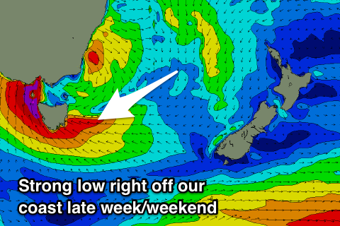
Windy stormy swells developing from late week
Eastern Tasmania Surf Forecast by Craig Brokensha (issued Friday 4th May)
Best Days: Tuesday midday south swell magnets, protected spots from the weekend
Recap
Small 1-2ft leftovers on Saturday with tiny surf into Sunday and flat today.
Today’s Forecaster Notes are brought to you by Rip Curl
This week and weekend (May 8 - 13)
Well, the outlook is finally positive for surf across our region.
The coming days will likely be tiny to flat.
There's the chance for a small spike in S'ly swell tomorrow midday from a very strong low passing under us this evening, but this will be fleeting.
Moving towards the end of the week though a mid-latitude low is forecast to develop across the south-east of the country, moving south-east and stalling off the Gippsland coast while deepening.
 We'll see a fetch of strengthening S/SE winds developing directly off our coast, generating a large building stormy SE-S/SE swell.
At this stage it looks like we'll see the low move off our coast Thursday afternoon, bringing strong to gale-force S/SE winds, easing into Friday as the lows centre moves back west,
This should result in an initial spike in S/SE swell Friday morning though with onshore E winds. Size wise we're looking at messy easing waves from 4-6ft or so.
Into Saturday we'll be subject to gale-force S/SE winds again, lasting all day and into Sunday. This will generate a larger SE swell through Saturday but with strong SE winds, with a large easing S/SE swell Sunday as winds start swinging back SW.
Now all this is subject to change depending on where the low is located, so check back here Wednesday for a clearer idea on the size and when conditions will improve.

