Building E'ly swell with onshore winds mid-late week, cleaner easing NE swell on the weekend
Eastern Tasmania Surf Forecast by Craig Brokensha (issued Monday 19th March)
Best Days: Saturday, Sunday morning
Recap
A good increase in NE windswell on Saturday mixed in with some easing S'ly groundswell and improving conditions. Sunday was a bit smaller but fun with offshore winds.
Today the surf is tiny to flat with strong offshores winds as a vigorous front pushes across us.
Today’s Forecaster Notes are brought to you by Rip Curl
This week and next week (Mar 20 - 25)
The surf will likely remain tiny tomorrow with a large W/SW groundswell pushing into the South Arm being too west to round the corner.
The tail of the frontal activity pushing across us is due to generate a weak fetch of SW tending S/SW winds up past us tomorrow evening, with a small weak S'ly windswell to 1-2ft expected but with poor S/SW tending E winds.
 We'll then see some small weak E'ly windswell building across the coast through Thursday and Friday as a strong high slides in from the west, squeezed by instability in the Coral Sea.
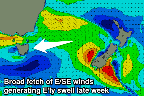
A broad fetch of strong E/SE winds will setup across the Tasman Sea, with building levels of E/NE swell due through Thursday, kicking to 2-3ft Thursday afternoon, peaking Friday to 3ft+ but with poor onshore E/NE-NE winds.
The E/NE swell is due to ease into the weekend, replaced with some NE windswell as the fetch in the Tasman Sea weakens and swings more NE in our swell window.
We're only looking at surf to 2-3ft as winds improve, swinging N/NW across the region. This isn't ideal but there should be some fun options across the region.
Sunday should see straighter offshore W/NW winds as the swell fades from a small 2ft.
Longer term we may see some new S'ly swell next week, but more on this Wednesday.

