Small N/NE swell for Thursday
Eastern Tasmania Surf Forecast by Craig Brokensha (issued Wednesday 13th December)
Best Days: Thursday
Recap
Not much south swell reported yesterday or this morning which is a bit of a shame, but we've got some fun N/NE windswell due through tomorrow.
Today’s Forecaster Notes are brought to you by Rip Curl
This week and weekend (Dec 14 - 17)
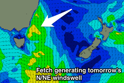
Into this afternoon and evening we'll see a strengthening fetch of N/NE winds down our coast as a cold front moving through the Southern Ocean squeezes a high in the Tasman Sea.
We'll see a broad and elongated fetch of strong N/NE winds developing in our swell window, moving away from us during tomorrow morning as the front pushes across us.
 North-east magnets should see fun waves peaking through the late morning/middle of the day to 2ft to possibly 3ft along with a NW tending W'ly wind and SE change mid-late afternoon.
Come Friday there no size is expected with fading 1-1.5ft sets early under a light offshore wind, similar Saturday.
Moving into next week and a weak surface trough developing off our coast Sunday looks to only generate a very tiny and weak S/SE windswell during the day, fading into Monday.
For the rest of the week there's nothing significant due, so try and make the most of tomorrow's small N/NE pulse.

