Excellent waves this week
Eastern Tasmania Surf Forecast by Craig Brokensha (issued Monday 4th December)
Best Days: Tuesday, Wednesday protected spots, Thursday, Friday morning
Recap
Building stormy swell through Saturday, becoming larger and stronger through Sunday as a very intense low formed off our coast. Protected spots were pumping though, similar into this morning as the swell started to ease.
Today’s Forecaster Notes are brought to you by Rip Curl
This weekend and next week (Dec 5 - 10)
The strong and intense low responsible for our current large S/SE swell is now weakening and moving east. With this we'll see winds improving and the S/SE swell easing, dropping back from 4-5ft across south magnets, smaller and 2ft to occasional 3ft.
Winds tomorrow morning should be SW for a period, tending SE through the day, while Wednesday a strong low drifting south from the Tasman Sea will bring strengthening S/SE tending S/SW winds.
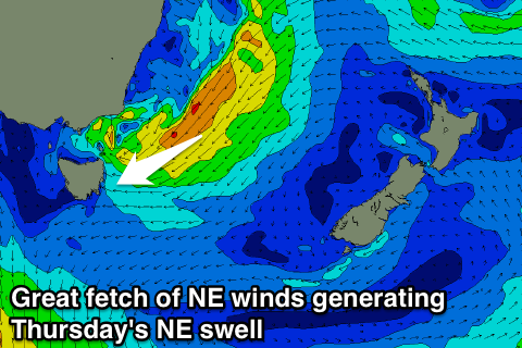
 As this low drifts south we'll see a great fetch of strong to gale-force NE winds aimed towards us, resulting in a moderate sized NE swell building later in the day, peaking Thursday morning.
Late in the day Wednesday we should see sets hitting 3ft or so later in the day, with 4-5ft sets Thursday morning, easing steadily through the day, further into Friday.
Conditions on Thursday will be excellent as the low continues to dip south, bringing offshore W/NW winds, ahead of weak sea breezes.
Friday will be clean again, but a surface trough moving in from the west will bring a S'ly change and small increase in S'ly windswell.
This windswell will fade into the weekend, with only a small pulse of distant groundswell for Sunday.
Longer term there's nothing too significant on the cards, so make the most of this week!

