NE swell continues

Eastern Tasmania Surf Forecast by Craig Brokensha (issued Wednesday 22nd November)
Best Days: Friday morning, later Sunday keen surfers, early Monday southern corners
Recap
A small mix of background E/NE swell and N/NE windswell the last couple of days, maxing out at 1-2ft.
Today’s Forecaster Notes are brought to you by Rip Curl.. which is convenient timing for a shameless plug, given the recent upwelling event (from persistent NE winds) that plunged local sea temps. Early Xmas present/new steamer perhaps? Clicky clicky for more.
This week and weekend (Nov 23 - 26)
We're looking at a touch more energy out of the NE through Friday now, with the weak persistent fetch of NE winds that are currently being aimed in our swell window due to strengthen through tomorrow afternoon and evening.
Tomorrow will likely hang around 1-2ft, but Friday morning should reveal better 2ft+ sets, easing through the afternoon.
 The swell is then expected to fade further into Saturday to 1-1.5ft.
Winds both early tomorrow and Friday morning should be light from the NW ahead of afternoon sea breezes (strongest tomorrow afternoon and from the N/NE).
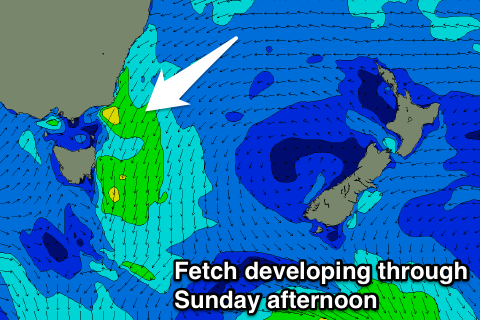
As talked about last update, another strengthening fetch of NE winds down our coast through Sunday should see the N/NE windswell build again, reaching 2-3ft into the afternoon though with gusty N'ly winds, easing rapidly Monday from 2ft with a S/SW tending S/SE change.
This change will be linked to a weak surface trough and some small weak S/SE windswell is expected later Monday and Tuesday morning but to no major size and with poor winds.
Longer term some new NE windswell is likely again mid-week, but more on this Friday.