Small weak N/NE windswells
Eastern Tasmania Surf Forecast by Craig Brokensha (issued Wednesday 15th November)
Best Days: Thursday morning southern corners, Friday morning north-east magnets, northern corners over the weekend
Recap
Tiny start to yesterday with a building N/NE windswell through the afternoon, peaking today to a good 3ft. Conditions are OK for northern corners, though we are still likely to see a S/SW change across the southern half of the coast around dark this evening.
This week and weekend (Nov 16 - 19)
Later today's change will be linked with a surface trough edging in from the west, though this trough is now forecast to sit a little further away from us, resulting in only a small weak S/SE windswell tomorrow.
We may see northern ends of beaches reaching 2ft+ into the afternoon, tiny early with a small leftover NE windswell to 2ft. Conditions are looking poor with a fresh S/SE tending SE breeze.
 As talked about on Monday, the trough will weaken and we'll see the N/NE fetch re-establishing in our north-east swell window through Friday and Saturday but it'll be weaker than our current setup and less favourably aligned.
As a result, weaker and smaller amounts of NE swell in the 2ft range across north-east magnets Friday and Saturday, fading Sunday.
Winds Friday will hopefully be variable early before coming up from the NE, out of the NE all day Saturday and then N/NW tending NE both Sunday and Monday.
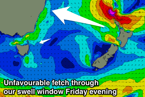
Into early next week, a tropical low developing just off the tip of New Zealand's North Island will generate an unfavourably aligned fetch of SE gales towards the East Coast.
No major size is expected off this low at this stage, though if the fetch tends a little more towards us we should see some fun E/NE groundswell, more on this Friday though.

