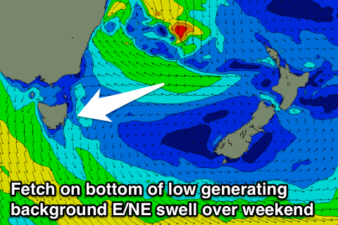
Mix of N/NE and E/NE swells for the weekend
Eastern Tasmania Surf Forecast by Craig Brokensha (issued Wednesday 25th October)
Best Days: Saturday afternoon/evening, Sunday morning, early Monday
Recap
Tiny waves yesterday with light winds through the morning, onshore today with a south-east breeze.
This week and weekend (Oct 26 - 29)
Today's south-east breeze is linked to a surface low moving in from the west across the country, with it deepening as it moves off the East Coast tomorrow.
We're now due to see a fetch of strong E/SE winds across the lows southern flank placed slightly more in our swell window, producing a small pulse of E/NE swell for later in the day Friday and the weekend.
This swell won't reach any major size and will be hidden under a building N/NE windswell through Friday evening and Saturday as a strong front pushing in from the west squeezes a strong high sitting between the Tasman Low and our coast.
 A peak in size is expected on Saturday morning to 3ft+ across north-east facing beaches, easing into the afternoon and further Sunday.
As the swell fades Sunday this is when we'll likely see the small E/NE swell from the low still in the water. Sets are only due to be in the 2ft range, fading back Monday. There'll also be a small N/NE windswell in the water Monday morning but only to 1-2ft and fading rapidly.
Coming back to the expected winds, and Saturday should see a morning N/NW breeze swinging more W/NW through the afternoon and S just before dark, favouring those north-east facing spots.
Sunday will then see N/NW tending stronger N/NE winds into the afternoon, followed by NW tending W/NW winds Monday.
Longer term there's nothing major on the cards besides small weak levels of E/NE swell, but we'll have a look at this again on Friday.

