Clean easing N/NE windswell tomorrow, small S swell for the weekend
Eastern Tasmania Surf Forecast by Craig Brokensha (issued Wednesday 11th October)
Best Days: Thursday, Sunday morning at south magnets
Recap
Monday's E/SE groundswell dropped back rapidly overnight leaving tiny and inconsistent 1-1.5ft waves across the coast yesterday, back to 0.5-1ft today.
Into this afternoon and more so evening we should see some new N/NE windswell building across the coast as winds strengthen from a similar direction.
This week and weekend (Oct 12 - 15)
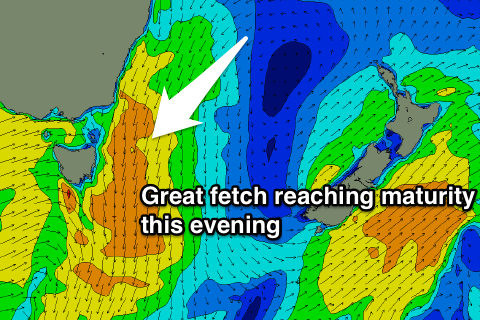
This afternoon's strengthening N/NE winds will be associated with an elongated and broadening fetch of strong N/NE winds forming down the southern NSW coast.
This fetch will reach maturity this evening with the fetch moving away from us during the early hours as a strong cold front moves in from the west.
 We'll see a peak in NE swell tomorrow morning, coming in at 3ft across north-east facing beaches, with the odd possible bigger one at dawn. The swell will ease steadily and gusty W/NW winds will create great conditions.
Come Friday there's no size due to be leftover with tiny clean conditions.
Into the weekend we're looking at small flukey pulses of refracted S'ly swell energy, the best aligned peaking Sunday morning.
Saturday's swell isn't too significant and will come hard around the corner from the Southern Ocean, maybe offering 1ft to occasionally 2ft sets at south magnets. Sunday morning's swell will be produced by a better aligned fetch of polar SW gales, with fun consistent 2ft sets likely across south facing beaches, easing through the day.
Winds look good each morning before sea breezes kick in.
Longer term we're looking at another N/NE windswell event mid-week, but more on this Friday.

