Good east swell to end the week, southerly swell next week

Eastern Tasmania Surf Forecast by Craig Brokensha (issued Wednesday 2nd August)
Best Days: Thursday morning, Saturday, next week
Recap
A weak increase in S/SE swell through yesterday, but today a broad and deep Tasman Low produced the first pulse of E/SE swell for our region.
The swell came in a little earlier than expected with the low generating a stronger than forecast fetch of E/SE gales in our swell window.
This week and weekend (Aug 3 - 6)
With today's first pulse of E/SE swell coming in a little ahead of schedule, it won't affect the rest of the week's forecast.
Last night and today a broad fetch of strong E/SE winds remained well aimed in our eastern swell window.
Moderate levels of E/SE swell should persist tomorrow to 3-4ft+ across open beaches, easing back from 3ft Friday morning. Winds are looking good tomorrow morning with a light W'ly offshore, tending fresh NE into the afternoon.
 This will be linked to another mid-latitude low moving in from the west, directing a short-lived fetch of strong E/NE winds into us overnight and Friday morning, weakening later in the day.
This will produced some poor E/NE windswell but not above the size of the E/SE swell and only to a weak 3ft or so.
Winds will be onshore from the E/NE with this low most of Friday, tending N/NE later in the day.
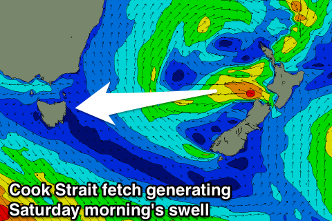
Come Saturday a strong offshore change will move through from the W/NW with an easing mix of swells from 2-3ft. One of these swells will be some longer-period energy from a burst of strong to gale-force E'ly winds exiting Cook Strait.
Longer term we're looking at a good S'ly swell mid-week as a storm moving in from the west projects a slow moving fetch of S/SE gales up through our southern swell window early next week.
More on this Friday though.