Great end to the week

Eastern Tasmania Surf Forecast by Craig Brokensha (issued Monday 10th April)
Best Days: Thursday, Friday, Saturday, Sunday
Recap
Nothing to report on Saturday, while a small pulse of NE swell was seen yesterday, providing a bit of action at magnets.
A S'ly change kicked up a small weak windswell this morning but with no quality. A further increase in size was seen today as a low deepened to our north-east but nowhere near model expectations (with the strongest winds being north of our swell window).
This week and weekend (Apr 11 - 14)
Any increase in S'ly windswell seen today should ease back tomorrow as the low to our north-east pushes further east and weakens.
South magnets might see 1-2ft sets but S'ly winds will create poor conditions.
We'll see some better swell from Wednesday afternoon and more so Thursday/Friday as broader Tasman Low takes shape through the Tasman Sea.
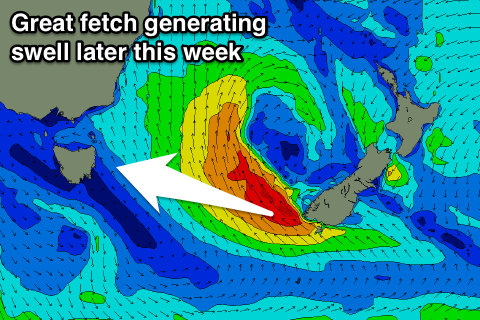 As this low broadens and deepens, a great fetch of gale-force SE winds will develop to the west of New Zealand's South Island, persisting with strength from tomorrow evening through Thursday morning, weakening a little while tending more E/SE.
This should produce a moderate sized E/SE swell event, showing later Wednesday to possibly 2ft, but building more noticeably Thursday from 2-3ft to 3-4ft+ later in the day. Friday morning looks best with 3-5ft sets, easing off very slowly into the afternoon, down steadily from 3ft Saturday morning.
Conditions look good Thursday with a light NW offshore wind, increasing through the day with an approaching front, and then W/SW tending SW winds Friday, similar Saturday.
Some new SE swell is on the cards for Sunday as a fetch of weak SE winds are projected towards while the low weakens and breaks down Friday and early Saturday.
2-3ft sets are on the cards with favourable N/NW winds.
Longer term a N'ly swell for Monday looks to north to generate any major size, therefore make the most of the swell this Thursday and Friday.