Peak in SE swell tomorrow morning

Eastern Tasmania Surf Forecast by Craig Brokensha (issued Monday 2nd January)
Sign up to Swellnet’s newsletter and receive the Eastern Tasmania Forecaster Notes and latest news sent directly to your inbox. Upon signup you'll also enter the draw to win a surf trip to P-Pass for you and a mate. It doesn’t get much easier so click HERE to sign up now.
Best Days: Tuesday morning, Wednesday morning, Thursday morning keen surfers, Sunday morning
Recap
Small 1-2ft waves leftover from Friday on Saturday morning with glassy conditions, while Sunday was tiny and bumpy.
Today a new SE groundswell started to fill in with good clean 2-3ft sets across the coast, and a further increase should have been seen this afternoon although with S/SE winds.
This week and weekend (Jan 3 - 8)
The source of today's building SE groundswell was a persistent but easterly tracking fetch of east-southeast winds through our south-eastern swell window.
This fetch over the weekend has since moved out of our swell window, with a very small fetch of SE winds lingering off New Zealand's South Island not expected to generate much swell.
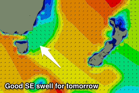 We should see a peak in size tomorrow morning to 3-4ft across open beaches, easing off slowly through the day and further from 2-3ft Wednesday morning, 1-2ft Thursday.
Winds tomorrow morning should be SW early, tending SE through the day, with variable tending NE winds on Wednesday, similar Thursday.
Into the end of the week there's nothing significant on the cards, but some N/NE windswell should develop through the weekend.
At this stage the length and strength of the fetch from the north-east in our swell window will be limited and only sets to 2ft are likely, but we'll have another look at this on Wednesday.