Good N/NE windswell tomorrow afternoon, strong S'ly swell to follow
Eastern Tasmania Surf Forecast by Craig Brokensha (issued Wednesday 7th December)
Best Days: Late Thursday, protected spots Friday afternoon, Saturday, dawn Sunday at south magnets
Recap
Tiny waves the last couple of days, with some decent swell to come.
This week and weekend (Dec 8 - 11)
Tomorrow's N/NE windswell event is looking good, with a fetch of strong N/NE winds due to developing through our swell window tomorrow morning, kicking up 2-3ft waves at north facing beaches into the afternoon (tiny early).
 Winds will be poor through the morning but a late afternoon NW change should create good conditions at open beaches later in the day.
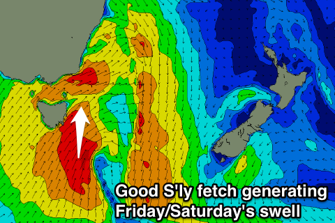
The swell should be gone by Friday morning, but a strong cold front pushing across us will project a fetch of strong to gale-force S/SW winds up past our south-east coast and through our southern swell window.
A moderate sized S'ly swell will develop quickly through Friday, building to a messy 4-5ft across south facing beaches into the afternoon but with S/SW winds.
The cold front and forming low to our south-east will be slow moving, leaving plenty of size for Saturday morning, with easing surf from 3-5ft expected at south magnets, down to 2-3ft into the afternoon and 1-2ft Sunday morning.
A straight W'ly wind is due Saturday morning, likely variable into the afternoon with a W'ly tending S'ly wind Sunday.
Longer term there's nothing significant on the cards until possibly later next week, but more on this Friday.

