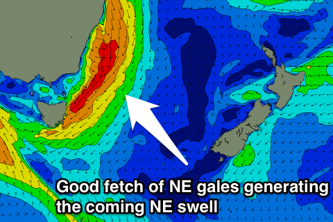
Large stormy NE swell building tomorrow, cleaner and easing Friday
Eastern Tasmania Surf Forecast by Craig Brokensha (issued Wednesday 28th September)
Best Days: Northern corners tomorrow afternoon, Friday morning, Saturday morning
Recap
Tiny waves yesterday and today, but it's the calm before the storm with a large stormy NE swell due through the end of the week. More below.
This week and weekend (Sep 27 – Oct 2)
Currently a severe low is impacting South Australia and will start moving east tomorrow, squeezing a strong high in the Tasman Sea.
This will result in a fetch of gale to severe-gale N/NE tending NE winds to be aimed down and into our coast tomorrow resulting in a rapid increase in NE swell through tomorrow.
 The surf should build steadily through the day with gale-force NE winds and building to 6ft+ late in the day.
A peak is due overnight and the swell will ease rapidly through tomorrow as the low drops south-east through Friday, easing from 4-5ft+ down to 3ft+ through the afternoon.
Winds should be offshore from the NW Friday morning with E/NE breezes developing into the afternoon.
The swell will continue to clock east into Sunday while easing as a result of the low and fetches of E'ly winds through our swell window drifting to the south. Open beaches should drop from 2-3ft under fresh W/NW winds.
Longer term there's nothing significant at all on the cards so make the most of the coming days.

