Fading surf tomorrow, large pulse Thursday afternoon
Eastern Tasmania Surf Forecast by Craig Brokensha (issued Monday 25th July)
Best Days: Tuesday morning, Thursday afternoon, Friday morning
Recap
A weekend of two halves with flat conditions Saturday and then pumping waves yesterday with a mix of S'ly and building S/SE groundswell under offshores.
Today the S/SE groundswell was easing back from 3-5ft under offshore winds.
This week and weekend (Jul 26 - 31)
The low pressure system responsible for our current S/SE groundswell moved off to the east out of our swell window yesterday. This will result in the swell continuing to ease overnight, further tomorrow from 2ft to possibly 3ft, tiny into the afternoon. Conditions will be clean again under fresh W/NW winds.
A strong mid-latitude front will dip across us tomorrow, but the fetch from the system looks to be too west to generate any size for our coast.
This will continue to be the case into Wednesday.
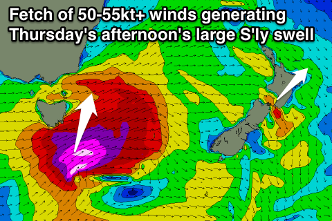
 Thursday however sees a very strong and powerful mid-latitude storm pushing across the state.
Current forecasts have a fetch of storm-force SW winds pushing from south-west to north-east (past the south-east corner of the state) during Wednesday evening and early Thursday.
This should produce a large S'ly groundswell for Thursday afternoon, reaching 4-6ft at south swell magnets before dark, but easing rapidly into Friday due to the quick eastward track of the storm. Only 3ft+ leftovers are due into Friday morning with offshore W/NW winds due through most of this period.
Into the weekend there's not too much expected across the state with a small refracted S'ly pulse possible Saturday, fading Sunday. More on this in Wednesday's update.

