Easing E/NE swell, replaced by S'ly swell
Eastern Tasmania Surf Forecast by Craig Brokensha (issued Friday 10th June)
Best Days: Saturday open beaches, Sunday and Monday south facing breaks, late week
Recap
Solid clean pumping waves continued yesterday across the coast, more manageable than the previous days.
This morning the swell was back even further with leftover 3ft surf and the odd bomb at times.
This weekend and next week (Jun 11 - 17)
A reinforcing pulse of E/NE groundswell due through today wasn't present at dawn, and with only 3ft sets reported across the coast, a downgrade in the size due tomorrow has been made.
 We should see fun but easing and inconsistent 2-3ft sets at open beaches under gusty W/SW tending SW winds. Head to southern corners for the most size.
The easterly swell will then fade further into Sunday, with 1-2ft background sets.
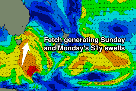
Some new S'ly windswell is due to develop very late in the day Saturday with a gusty S/SW change, but peak Sunday morning with 3ft sets at south facing beaches.
A trailing fetch of polar SW gales should also produce a reinforcing S'ly groundswell pulse for the afternoon, again to 3ft before easing 2ft to possibly 3ft Monday morning.
Conditions Sunday and Monday look great for south facing beaches with an offshore W/NW breeze persisting both days.
As the S'ly swell fades Monday, some very inconsistent and distant E/NE groundswell is due from a fetch of NE winds currently above New Zealand's North Island.
This isn't expected to offer any major size with peaking Tuesday to a very inconsistent 2ft at open beaches.
For the rest of the week we're looking at tricky and unfavourably aligned refracted S'ly groundswell pulses. No major size is due off the first episode Wednesday, but a better aligned polar low may generate a better swell for Friday. More on this Monday, have a great weekend!

