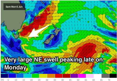
Large NE swell peaking on Monday, poor winds
Eastern Tasmania Surf Forecast by Guy Dixon (issued Wednesday June 1st)
Best Days: Protected bays from Sunday.
Recap:
Southeasterly energy provided clean and workable 2ft sets under a northwesterly breeze on Tuesday morning, deteriorating as a seabreeze developed in the afternoon. Today, that size has eased to the 1-2ft range, with a similar northwest, tending easterly wind scenario.
This week (Thursday 2nd - Friday 3rd):
Small hints of refracted energy will be the main source of swell on Thursday, generated by a southerly fetch which has been intensifying over central parts of the Tasman Sea overnight. Unfortunately, it’s likely to be undersized and insignificant, fading into Friday.
A light/variable-west/southwest breeze will allow for clean conditions early, tending light onshore later.
Open beaches may also see a tiny amount of easterly energy build on Friday as a weak, local easterly fetch sets up, but as a whole, the remainder of the week isn’t expected to see much more than 1ft, with much stronger energy likely over the weekend and into next week.
Again, breezes should be light/variable-west/northwesterly early, before giving way to an east/northeasterly breeze.
This weekend (Saturday 4th - Sunday 5th):
In contrast to the end of the week, models are still gunning for an oversized northeasterly swell to build late on the weekend generated a northeasterly fetch stretching all the way to the islands of the South Pacific.
This broad and elongated northeasterly fetch should already be steering 35-40kt winds off the coast of NSW by late on Saturday night, causing the swell to build to around 3-4ft at northeast facing locations by the late afternoon, larger after dark.
Local northeasterly winds are likely to have an impact on wave quality, making it tricky to find a decent wave.
The surf should continue to build throughout Sunday to a stormy 10ft as this fetch intensifies and pushes right into the coast of northeastern Tasmania.
Next week (Monday 5th onward):
 This large scale system is forecast to intensify further, becoming similar to a setup we saw nearly a decade ago off the coast of NSW. Core winds of up to 50kts are on the cards for late Sunday evening and into Monday morning, projecting with good alignment to the region.
Exposed northeast facing beaches have the potential to build to a very solid 12-15ft on Monday afternoon, with only some models suggesting a late northwesterly airflow as a low passes over the region. I wouldn’t put too much faith into this scenario.
Despite easing slightly, Tuesday should still be offering large sets in the 10ft+ range at exposed beaches.
One of the more interesting aspects of this swell event is its duration. Strong and elongated fetches look to remain established over the Tasman Sea and South Pacific, with great alignment continuing. Furthermore, multiple intensifications around small lows developing within the broader flow will maintain regular pulses, providing strong energy on Wednesday morning, reinforcing in the evening and into Thursday.
Breezes are likely to back off throughout Tuesday and Wednesday, although there is very limited confidence in the wind scenario. Some models suggest northwesterly breezes each morning, others have northeasterly winds persisting.
I’m afraid we will have to give it a few days before models agree.


Comments
What an event... was lucky enough to see TC Funa's swell make landfall on this great coast, that was solid as... I'm trying to imagine up to double that, even if winds will be very different
Holy shitchips batman , cheers for forecasts guy, will you be updating situation on Friday? Only asking because you've missed the last couple of Fridays
Yeah mate. Craig will be updating the forecast on Friday.