Strong S'ly swell building Sunday, cleaner and easing Monday
Eastern Tasmania Surf Forecast by Craig Brokensha (issued Friday 15th April)
Best Days: Sunday midday onwards, Monday south facing breaks, Wednesday morning, Thursday morning
Recap
A fun clean but inconsistent pulse of S'ly groundswell yesterday with decent offshores during the morning, while today the swell was back to a smaller 1-2ft but nice and clean again.
This weekend and next week (Apr 16 - 22)
Tomorrow isn't expected to offer much size with a tiny fading N'ly windswell probably not above 1ft, and a building S/SE windswell only to maybe 2ft later in the day but with onshore S/SE winds.
Of greater significance is a pulse of S'ly groundswell for Sunday, generated by a strengthening polar frontal system that's currently to our south-west.
A fetch of severe-gale to storm-force SW winds will be generated within our southern swell window, with a long-period and strong S'ly groundswell due to arrive through the middle of the day and reaching 3-5ft across south swell magnets into the afternoon.
Winds will be an issue though with a morning W'ly due to give into afternoon E'ly sea breezes, so keep this in mind, with the swell not due until around midday.
Monday will be cleaner as the swell eases back from 3ft or so under a W/NW tending fresh N/NW breeze.
Also in the mix Sunday afternoon and Monday will be some small E/NE swell from a persistent fetch of E'ly winds off New Zealand's North Island. This will provide infrequent 2ft sets across open beaches as it peaks Monday, fading into Tuesday.
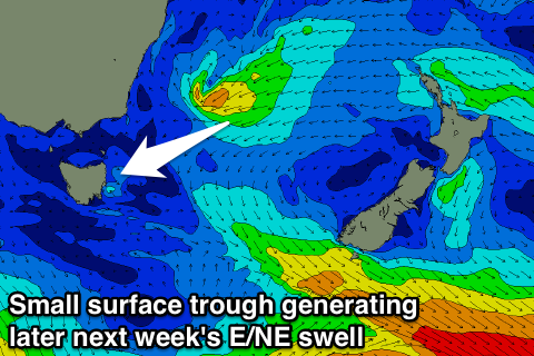
 Into the middle to end of the week some new E/NE swell is due to build from Wednesday afternoon, peaking Thursday as a deepening and southward drifting surface trough in the Tasman Sea aims a fetch of strong E/NE winds towards us.
The swell is due to peak Thursday around a good 3ft+ across open beaches with offshore winds, but we'll have another look at this Monday as the models are still moving around regarding this system. Have a great weekend!

