S'ly pulses with hints of E'ly swell over the weekend
Eastern Tasmania Surf Forecast by Guy Dixon (issued Wednesday 13th April)
Best Days: Sunday morning.
Recap:
Tuesday morning saw fun option filling in across the south swell magnets with clean sets in the 3ft range under a northwesterly breeze, smaller at the less exposed breaks. A seabreeze kicked in during the late morning, causing conditions to deteriorate.
Today, the surf has eased back to the 1-2ft range, with less favourable breezes leading to poor conditions.
This week (Thursday 14th - Friday 15th) and this weekend (Saturday 16th - Sunday 17th):
The Southern Ocean looks to be the main source of swell over the coming days, with regular fronts providing a number of pulses with varying quality.
South facing beaches can expect sets in the 2ft range on Thursday morning generated by poorly aligned fetches following a polar frontal progression which has been moving over the deep Southern Ocean overnight with core fetches of up to 45kts.
Long range energy should also fill in across the magnets generated by distant frontal progression over the Indian ocean earlier in the week. Sets are likely to be very inconsistent and fairly modest in size, occasionally breaking at around 1-2ft by the afternoon.
Light west/northwesterly breezes are on the cards for Thursday morning tending light northerly and eventually northeasterly as the day progresses.
Friday is looking much cleaner as northwesterly breezes dominate preceding a front, although we are likely to be in between swells with onlyhints of building easterly energy filling in as a result of a building Tasman ridge.
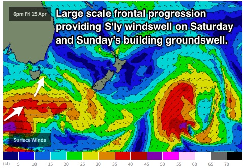
A southerly change is then expected to move locally, whipping up a southerly windswell throughout Saturday to around 2ft+, all part of a much broader frontal progression.
 This system looks to enter the far swell window late on Friday with broad southwesterly trailing fetches of around 45-50kts. Two pulses are expected off this main system, first a mid-range swell off the leading edge, with stronger energy off the broader, more substantial trailing fetches.
As a result, south facing beaches should build to a late peak in the 3-4ft+ range on Sunday afternoon.
Meanwhile, hints of east/northeasterly energy should also be building across open beaches as a result of a stationary southeasterly fetch steered by the aforementioned Tasman ridge. Small intensifications should provide a pulse to around 1-2ft on Saturday, with a second better pulse due Sunday to 2ft across open beaches.
Open beaches should offer a workable wave under a southerly component breeze on Saturday, with local winds tending southwesterly at times, however size will be limited at these locations.
Sunday morning is looking much better under a west/southwesterly breeze, swinging onshore later.
Next week (Monday 18th onward):
Trailing fetches off the back of the previous front should maintain energy throughout the early stages of next week, slowing an otherwise easing trend. South facing beaches will fade from around 3ft on Monday, further from the 2ft range on Tuesday.
The early session will offer the cleanest conditions each day, with northwesterly breezes likely to precede an afternoon seabreeze.
More detail on Friday.

