One final pulse of E/NE groundswell mid-week, sizey NE windswell Thursday
Eastern Tasmania Surf Forecast by Guy Dixon (issued Monday 25th January)
Best Days: Tuesday, hopefully Thursday morning, more likely Thursday afternoon.
Recap:
An very inconsistent east/northeasterly groundswell generated by Victor increased along the open beaches to the 3ft range by Saturday afternoon, holding on Sunday and throughout today.
Breezes started off clean at virtually all spots on Saturday under a northwesterly airflow, tending southeasterly and increasing from mid-late morning. Sunday was limited to protected southern corners for the majority of the morning, before deteriorating virtually everywhere. Finally, today has been under a southerly airflow all day limiting options to the south ends out of the wind.
This week (Tuesday 26th - Friday 29th):
Victor’s groundswell is expected to continue this week, ebbing and pulsing slightly as a result of brief attenuations and intensifications of the system as it has drifted south over the past few days.
Sets should ease from the 2-3ft+ range across the open beaches on Tuesday, a slight decrease in size in comparison to today. Breezes will start off light/variable, tending southeasterly and increasing ever so slightly into the afternoon.
Victor was at it’s weakest and least structured throughout the weekend, which should in turn result in the surf fading further into Wednesday, with occasional sets easing from the 2-3ft range. Breezes should become less favourable, increasing from the northeast throughout the day, making it hard to find a clean wave across open beaches where most of the swell is filling in.
However, we are expecting a slight pulse on Thursday morning following an intensification which showed up on today’s satellite pass.
Easterly core fetches of up to 50kts which showed up on satellite overnight should provide a small amount of energy, but largely blocked by the North Island of New Zealand. Open beaches early on Thursday should see around 1-2ft off this pulse.
This system is expected to continue moving south, with New Zealand casting more of a swell shadow for Tasmania. This is no great loss however, because models are also indicating that this system is due to weaken fairly rapidly, with its swell generating potential dwindling.
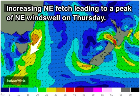
A Tasman ridge is expected to build throughout the week with the pressure gradient tightening between an inland trough. This pressure gradient will steer an increasing easterly airflow, ultimately swinging northeasterly and becoming stronger from Tuesday.
Initially, easterly breezes tending east/northeasterly of around 20-30kts look to be well aligned to northeastern Tasmania late on Tuesday into Wednesday, providing low quality wind affected options in the 4ft range by Wednesday afternoon.
 This fetch is only forecast to increase and broaden overnight, peaking in the 4-5ft range on Thursday morning, limited only by the fact that this fetch no longer hugs the coast.
Breezes have the potential to be fairly gusty onshore at day break on Thursday, however most models are picking a winds of light offshore breezes winds late morning/afternoon, tending northwesterly late.
This window of favourable breeze has quite a high chance of varying in coming model updates as it is at the mercy of the position/timing of a low developing.
Secondly, breezes will need a fair amount of time to iron out any scarring from multiple days of gusty onshore breezes.
The wind outlook for Friday is even more contrasting between models, so we will focus on that in coming updates.
This weekend (Saturday 30th - Sunday 31st):
Early, but fairly uncertain indications show that we should have northeasterly energy in the water over the weekend, generated by a tight pressure gradient squeezed between a trough over eastern Australia and a a ridge over New Zealand.
It’s by no means an ideal set up, but we may see options in the 3-5ft range, peaking sometime on Saturday afternoon.
I’ll leave any details out until the situation firms up. It’ll most likely change.

