Southerly groundswell for next week
Eastern Tasmania Surf Forecast by Guy Dixon (issued Friday 23rd October)
Best Days: Tuesday morning, Thursday morning at protected spots.
Recap:
It was only modest, but open beaches along northeastern Tasmania picked a small increase in swell from the northeast with sets nudging the 2ft mark. It wasn’t much, but coupled with workable northwesterly breezes, select spots saw the most significant swell in a couple of weeks.
The swell has faded today, with sets approaching the 1.5ft mark at open beaches. Conditions remain clean and workable however under light northwesterly breezes.
This weekend (Saturday 24th - Sunday 25th):
Poorly aligned frontal activity will be the only swell input across the weekend. Exposed south facing beaches are only expected to pick up inconsistent sets in the 1ft range on Saturday afternoon, potentially cracking the 2ft range on Sunday morning.
Conditions will be clean on Saturday morning under a light west/northwesterly breeze, becoming variable before tending light onshore by early afternoon. Sunday is likely to wake to light/moderate north/northwesterly breezes (possible northwesterly) before increasing from the north for the remainder of the day.
Next week (Monday 26th – Friday 30th):
We are still on track for a much more dynamic week ahead.
A brisk southerly change will move up the coast overnight from Sunday into Monday. A short range southerly swell will rapidly increase in the wake of this change allowing south facing beaches to build into the 4ft range by the late afternoon. Quality will be lacking due to the prevailing southerly wind direction limiting options heavily. Protected southern corners will see virtually none of this size as the periods will be lacking.
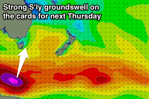
A stronger southwesterly fetch associated with this front over the Southern Ocean will steer 35-45kt core winds generating a southerly groundswell due to peak Tuesday morning.
South facing beaches are expected to be offering sets in the 3-4ft range in the morning under a light south/southeasterly breeze (possibly variable in places). There should be workable options up and down the coast with winds not having too much influence on the quality. Time will be of the essence however, as breezes will soon swing light/moderate easterly.
The swell is expected to fade throughout Wednesday to the 2ft range under light northeasterly breezes, preceding a solid pulse of southerly groundswell on Thursday.
 Broad west/southwesterly fetches moving with a frontal progressions across the Southern Ocean have poor alignment, however their 40-45kt core winds are still expected to generate sufficient sideband energy for a southerly groundswell to build to the 3-4ft range on Thursday afternoon.
Similarly to Tuesday’s swell, a light/moderate southeasterly breeze will be dominating the coast. This time, the quality will be impacted slightly, so more protected beaches will have the best options. Solid periods should allow for sufficient refraction into protected bays.

