Southerly swell regime into the end of the week
Eastern Tasmania Forecast by Craig Brokensha (issued Monday 3rd August)
Best Days: Early Tuesday for desperate surfers, Thursday morning, Friday morning, Saturday, Sunday
Recap
Flat with no swell to speak off under the current progression of frontal systems.
This week (Aug 4 - 7)
A small spike in S'ly swell is still on the cards for tomorrow morning, generated by a vigorous front generating a burst of S'ly gales up past us this afternoon and evening.
The swell will drop rapidly from 2ft or so across south facing beaches, becoming tiny into the afternoon with W/NW winds.
The next surfable day will be Thursday when a broad polar front pushes up past us Wednesday, with a fetch of strong to gale-force SW winds being generated in our southern swell window.
 This should offer better 3-4ft sets across south swell magnets, before easing back through Friday.
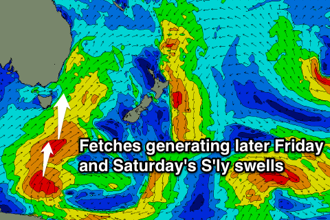
Into Friday afternoon and Saturday though, some better S'ly groundswell is due, from a trailing fetch of S/SW gales through our southern swell window Thursday and Friday.
This should kick south facing beaches back to 3ft later in the day, easing Saturday morning from 3-4ft.
Winds will be OK but not perfect and W/SW Thursday and Friday with W'ly breeze Saturday morning and NW to NE winds Sunday.
Longer term there's nothing major on the cards so you'll have to make the most of the swell due later in the week.

