Southerly swell for the period
Eastern Tasmania Forecast by Craig Brokensha (issued Monday 22nd June)
Best Days: Later Sunday, Monday morning, Wednesday, later next week
Recap
Generally tiny waves with no surfing options.
This weekend and next week (Jun 27 – Jul 3)
 The coming period is looking tricky, with short-lived pulses of refracted S'ly groundswell due from continued polar frontal activity under the country.
Most of this activity will be quite zonal and only small pulses are due.
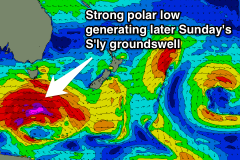
The weekend is expected to be generally tiny besides one strong pulse of S'ly groundswell later Sunday afternoon.
This is being generated by a vigorous polar low racing in from the west, with a fetch of severe-gale to storm-force W'ly winds being generated in our southern swell window.
The alignment of the fetch and track is unfavourable but the strength will overrides this somewhat, with a strong late pulse of S'ly groundswell due later Sunday, reaching 3-5ft across south swell magnets.
The swell is then due to ease rapidly overnight, with only smaller fading 2-3ft sets left Monday morning under W/NW winds.
The next pulse of S'ly groundswell is due Wednesday, generated by a similar strength polar low pushing under the state early Tuesday morning.
The swell from this system should looks to be of similar order, peaking to 3-5ft across south swell magnets Wednesday morning and then easing into the afternoon under W/NW winds.
Into the end of the week the storm track is expected to become better aligned, with the help of the Long Wave Trough, with the frontal activity being more steered up through the southern Tasman Sea. This should generate some better aligned S'ly swell, but we'll have a closer look at this Monday. Have a great weekend.

