Small windows of clean conditions working around onshores
Eastern Tasmania Forecast by Craig Brokensha (issued Friday 13th February)
Best Days: Possible small window later Saturday, Monday from when winds start shifting offshore, Tuesday morning, Friday
Recap
A strong S'ly change moved through yesterday whipping up some windswell, while today a small weak E'ly windswell is building with fresh onshore winds.
 This weekend and next week (Feb 14 onwards)
There's plenty of swell due over the weekend but unfortunately onshore winds from the NE will limit surfing options to only the most protected northern corners, which will miss out on all of the size out of the E/NE and NE.
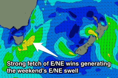
Firstly some long-range and inconsistent E/NE trade-swell is due to build through tomorrow and hold Sunday to 2-3ft at open beaches. But a larger NE windswell will develop as a surface trough deepens directly to our west, aiming a fetch of strengthen E/NE tending NE winds through our swell window.
This should result in building levels of consistent E/NE swell from 3ft+ during the morning with 5ft sets later in the day as winds swing from the E/NE to NE. There is actually a chance for variable winds or light offshores develop later tomorrow across the north half of the coast as the trough drifts south, so keep an eye on local wind observations.
A peak in E/NE swell is due Sunday to 4-5ft across north-east facing beaches but winds will continue to be a problem with a fresh N'ly-N/NE breeze expected most of the day across most locations.
Monday will be the day to surf though as a front pushes across the state bringing an offshore W'ly change late morning.
This should clean up an easing 3-4ft of E/NE swell, so again keep an eye on local wind observations and the coast for signs of this change.
The E/NE swell should taper off into the middle of next week and winds are expected to swing back onshore Tuesday. There's a chance for variable winds early in the day, with an easing 2ft to occasionally 3ft of swell, but we'll review this Monday.
Longer term we're looking at some good E/NE groundswell again late in the week as the weak easterly trade-flow through the Coral Sea restrengthens through early next week as a tropical depression drifting south from the New Caledonia region squeezes a broad high over New Zealand.
Some good but inconsistent 3ft of E/NE groundswell is likely off this development, but check back here Monday for an update on how this is tracking.

