Extended run of swell from the east

Eastern Tasmania Forecast by Craig Brokensha (issued Monday 25th August)
Best Days: Wednesday onwards
Recap
Small levels of NE windswell padded out the weekend to 2ft across open beaches with Saturday morning providing the best conditions with a morning NW'ly.
Today the swell was back to a tiny 1ft with a weak onshore wind.
This week onwards (Aug 26 onwards)
We've got a very active period ahead due to an autumnesque development in the Tasman Sea.
Currently a surface trough sitting off the SE Qld / Northern NSW coast, squeezing the northern flank of a strong high sitting in the Southern Tasman Sea.
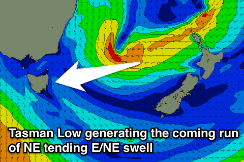 This trough will deepen further over the coming days while drifting slowly south (supporting the formation of a low pressure system) with a broad fetch of strong to gale-force E'ly winds developing in our north-eastern swell window.
The low is expected to remain strong while dipping towards New Zealand through the end of the week while remaining in our swell window at least through the weekend.
This should produce various pulses of NE tending E'ly swell through the coming period, the first strongest pulse through Thursday afternoon and Friday.
This pulse should come in at 3-4ft+ across exposed north-east facing beaches under NW tending NE winds. Before this though we should see a small increase in NE swell Tuesday afternoon with bigger 3ft to occasionally 4ft sets on Wednesday.
As the low slips further south it will become closer to us while maintaining its strength, producing a better pulse of E'ly groundswell later Saturday and Sunday/Monday. At this stage we're probably looking at 4-5ft+ of swell across the East Coast Sunday and Monday under offshore winds each morning.
There's still a bit of movement in the models and the forecast so check back here on Wednesday for a much more confident forecast on the timing and sizes of the coming easterly swell event.
Comments
Swell arriving now........ Don't be surprised if later in the week it tips the 6ft+ scale....
Yes, expect an upgrade this afternoon but not later this week, more so Saturday afternoon and Sunday. Models have upgraded as well.
Well it's wed... Id' consider later in the week fri/sat.......
My guess would be fri - 4 foot solid growing to 5 -6 foot late in the day......
Sat' morning - 6 foot going to 6 foot + by early arvo....
ps - The banjo redneck coast has been epic from what I've heard.......
Once Saturday hits it's the weekend, and I'd be surprised if the surf got to 6ft+ by close of play Friday, in actual fact we'll probably be on a downwards trend from a solid pulse through the morning.
Saturday late morning into the afternoon though looks very solid and in that 6ft+ range, so agree on that, but Saturday afternoon isn't later this week ;)
Is saturday next week????
Hmmm... Let's see... I would've called thursday "tomorrow"......... And Friday/Saturday "later this week"....... :p
Apart from this entertaining semantic battle, bottomline line is the surf will be bigger than the current models suggest, later this week... Whoops.... I mean END of the week... :)