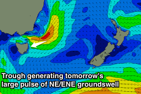
Large improving swell tomorrow afternoon; excellent Wednesday
Eastern Tasmania Forecast by Craig Brokensha (issued Monday 2nd June)
Best Days: Tuesday afternoon, Wednesday, Thursday for beginners
Recap
Friday's swell hung in at 2-3ft across swell magnets Saturday morning but this faded into the afternoon and further Sunday. A late increase in stormy NE windswell was seen and this came in at a messy 3-4ft across exposed spots today, but with poor onshore winds.
This week (Jun 2 – 6)
The surface trough responsible for today's NE swell deepened further this afternoon to our north-east with a fetch of NE gales generated on an active sea state while projecting towards us slightly.
 This should generate a large pulse of NE tending E/NE groundswell for tomorrow, filling in during the day and peaking through the afternoon to 5-6ft at exposed spots and there may be the odd bigger bomb at swell magnets.
Winds will also improve as the trough drifts south resulting in a swing from fresh onshore E'ly breeze around to a light SW'ly. It will probably take a while for conditions to settle down though, so don't expected anything too epic.
Wednesday on the other hand looks great with a fresh offshore wind, but the swell will drop rapidly due to the trough moving off to the east while weakening. Still, open beaches should pick of 3-4ft of swell before fading through the day and down to 1ft to possibly 2ft Thursday.
Come Friday there isn't expected to much surf left at all, so make the most of tomorrow afternoon/evening and Wednesday.
This weekend onwards (Jun 9 onwards)
The weekend is quite interesting as we could possibly see the first East Coast Low of the of the season forming off the mainland.
A contribution of factors including warmer than normal sea surface temperatures off the Southern NSW Coast, inflow of moisture from a broad and retrograding trade-flow from above New Zealand and upper level trough should see the formation of a low pressure system in the Tasman Sea.
The positioning and placement of this low will be crucial as the further north it develops, the less swell potential there will be for us. So at this early stage we'll sit on the forecast and have another look on Wednesday when the models should start to form on what's in store.

