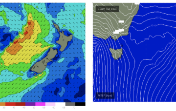
That low looks to be a monster of a system. As the deep low moves eastwards towards the North Island it aims up gales to severe gales back towards the east coast and we’re on track to receive some powerful swell from the E/NE through next week.
Primary tabs
/reports/forecaster-notes/eastern-tasmania/2025/07/28/small-swells-week-sly-winds-plenty-surf-the
freeride76
Monday, 28 July 2025
/reports/forecaster-notes/eastern-tasmania/2025/07/25/another-sizey-ne-windswell-over-the-weekend
freeride76
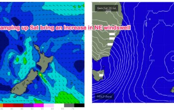
Friday, 25 July 2025
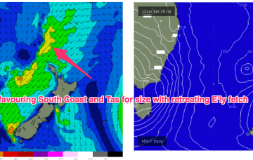
High pressure has drifted up over NENSW and into the Tasman and an approaching trough and cut-off low really ramps up the pressure gradient short term, leading to fresh/strong N/NE-N’ly winds off the coast.
/reports/forecaster-notes/eastern-tasmania/2025/07/23/another-sizey-ne-swell-the-weekend
freeride76
Wednesday, 23 July 2025
We’ll see the current pattern repeat as a pre-frontal N’ly flow ramps over the weekend before a front and low bring a stiff W’ly change.
/reports/forecaster-notes/eastern-tasmania/2025/07/21/sizey-ne-windswells-tomorrow-and-the-weekend
freeride76
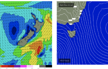
Monday, 21 July 2025
We’ll see N’ly winds increase short term and then as we head into the weekend in response to an approaching cut-off low in the Bight, with sizey pulses of NE windswell on the radar for these periods.
/reports/forecaster-notes/eastern-tasmania/2025/07/18/ne-swell-most-next-week-peaking-tues
freeride76
Friday, 18 July 2025
The rest of the week should hold surfable levels of E/NE-NE swell from winds feeding into a low pressure trough in the Tasman.

/reports/forecaster-notes/eastern-tasmania/2025/07/16/unusual-swell-source-over-the-weekend-ne
freeride76
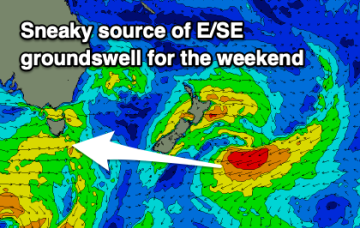
Wednesday, 16 July 2025
Tiny into tomorrow before a small kick in E/SE swell Fri from the low SE of the South Island which is currently on the edge of the swell window.
/reports/forecaster-notes/eastern-tasmania/2025/07/14/fading-south-swell-sneaky-east
Craig
Monday, 14 July 2025
The coming period looks very slow with today's south energy due to fade tomorrow. A sneaky, small east groundswell is due on the weekend.
/reports/forecaster-notes/eastern-tasmania/2025/07/11/winter-patttern-fresh-offshores-and-small-s
freeride76
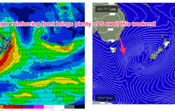
Friday, 11 July 2025
We’ll see a nice S pulses over the weekend as multiple fetches operate on an active sea state.
/reports/forecaster-notes/eastern-tasmania/2025/07/09/fun-e-swell-then-small-s-pulses-ahead
freeride76
Wednesday, 9 July 2025
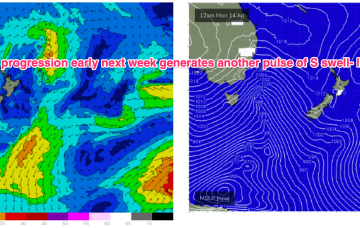
Compared to Mondays notes the outlook for S swell is improved, mostly due to a better aligned following front which conjoins the initial front and forms a slower moving low in the southern Tasman.
/reports/forecaster-notes/eastern-tasmania/2025/07/07/some-quality-the-ene-week-low-drifts-towards-nz
freeride76
Monday, 7 July 2025
Back up again Thurs from the E-E/NE as winds feeding into the low strengthen before slipping behind NZ.