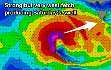
A complex series of powerful lows will track across Tasmanian longitudes from Monday onwards, delivering W/NW tending W’ly gales and building strong surf across the region.
Primary tabs
/reports/forecaster-notes/southern-tasmania/2019/03/21/small-until-monday-solid-and-windy-tuesday
thermalben
Thursday, 21 March 2019

/reports/forecaster-notes/southern-tasmania/2019/03/19/small-conditions-persist-some-time-solid-and
thermalben
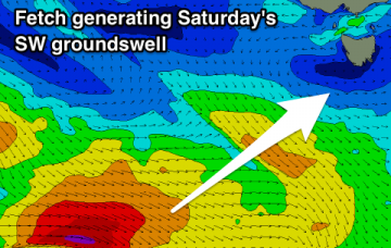
Tuesday, 19 March 2019
We’re in the midst of a regional blocking pattern with the main influence for our region being a stationary belt of high pressure across the Southern Ocean, stretching from underneath Western Australia through South Australia to a position below Tasmania.
/reports/forecaster-notes/southern-tasmania/2019/03/14/extended-run-small-surf-ahead
thermalben
Thursday, 14 March 2019
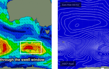
In Tuesday’s notes, I mentioned an intensifying polar low well below WA for Friday that had the possibility of generating a small unusual sideband SW swell for Sunday afternoon.
/reports/forecaster-notes/southern-tasmania/2019/03/12/solid-mid-week-swell-then-its-all-axis-while
thermalben
Tuesday, 12 March 2019
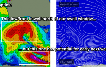
Although the synoptics look very impressive, this low is travelling a little more north in latitude than is ideal and this will impact size potential through the South Arm.

/reports/forecaster-notes/southern-tasmania/2019/03/08/large-swells-less-ideal-winds
Craig
Friday, 8 March 2019
No lack of surf over the coming period but winds will be tricky and variable.

/reports/forecaster-notes/southern-tasmania/2019/03/06/large-swells-inbound-varying-winds
Craig
Wednesday, 6 March 2019
Tons of swell on the cards though winds will vary and be favourable and unfavourable at times.

/reports/forecaster-notes/southern-tasmania/2019/03/04/strong-wsw-swells-period-and-plenty-more-surf
Craig
Monday, 4 March 2019
An active period of surf with moderate to large though westerly angled swells this period.
/reports/forecaster-notes/southern-tasmania/2019/03/01/small-tiny-weekend-better-swell-next-week
Craig
Friday, 1 March 2019
Small clean swell for tomorrow, then tiny until a strong though west swell builds mid-week.

/reports/forecaster-notes/southern-tasmania/2019/02/27/small-tiny-swells-period
Craig
Wednesday, 27 February 2019
Mostly tiny apart from a couple of groundswells from the south-west and west.
/reports/forecaster-notes/southern-tasmania/2019/02/25/couple-small-swells-period
Craig
Monday, 25 February 2019
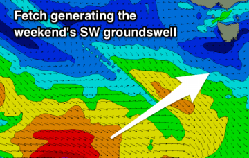
Small W/SW and SW swells this period, best on the weekend in regards to power, size and direction.