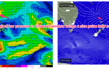
There’s actually a couple of E/NE swell sources for early next week. And a S'ly swell too!
Primary tabs
/reports/forecaster-notes/sydney-hunter-illawarra/2025/05/09/fun-waves-and-dynamic-synoptics-abound
thermalben
Friday, 9 May 2025
/reports/forecaster-notes/sydney-hunter-illawarra/2025/05/07/spike-in-s-swell-short-term-another
freeride76
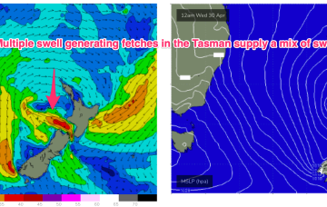
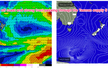
Wednesday, 7 May 2025
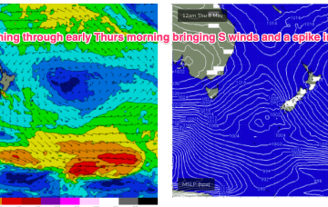
In between, a trough and cold front are currently approaching Tasmania, expected to bring a vigorous S’ly change o/night, bringing a spike in short range S swell short term.
/reports/forecaster-notes/sydney-hunter-illawarra/2025/05/05/spell-small-clean-surf-the-next-large
freeride76
Monday, 5 May 2025
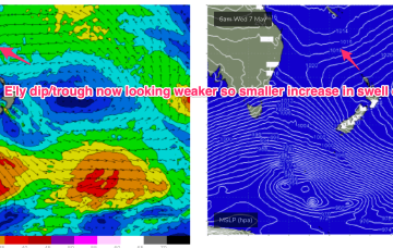
We’ll see the current dominant high (1034hPa) over New Zealand which is directing a broad trade fetch through the South Pacific and into the Coral Sea slowly migrate eastwards this week with an E’ly dip form a trough of low pressure due E of SEQLD mid week.
/reports/forecaster-notes/sydney-hunter-illawarra/2025/05/02/improving-conditions-over-the-weekend
freeride76
Friday, 2 May 2025
A dominant (1034hPa) high pressure system is currently moving off the Far South Coast into the Tasman Sea where it very slowly migrates south-eastwards over the weekend. Pressure gradients weaken over temperate NSW with a firm ridge in the sub-tropics holding a S-SE pattern over the weekend.
/reports/forecaster-notes/sydney-hunter-illawarra/2025/04/30/windy-s-swells-short-term-mellowing-out
freeride76
Wednesday, 30 April 2025
We’re seeing a ramp up in strong S’ly winds along the eastern seaboard as a dominant high (1035hPa) moves through the eastern Bight towards Tasmania with a trough on it’s leading edge moving northwards. Remnants of a low on the weekend are also sitting near New Zealand with swell generating fetches off the South Island and emerging from Cook Strait into the eastern Tasman.
/reports/forecaster-notes/sydney-hunter-illawarra/2025/04/28/another-vigorous-synoptic-pattern-week
freeride76
Monday, 28 April 2025
We’ll see things ramp back up again Wed. A front enters the Tasman, decays into a trough and moves northwards along the coast in a pattern we’ve seen repeatedly this autumn.
/reports/forecaster-notes/sydney-hunter-illawarra/2025/04/25/another-great-run-swell-ahead-though
thermalben
Friday, 25 April 2025
The synoptics are looking quite complex across the Tasman Sea, but the good news is that we’ve got plenty of waves on the way.
/reports/forecaster-notes/sydney-hunter-illawarra/2025/04/23/unstable-set-sees-another-low-form-the
freeride76
Wednesday, 23 April 2025
Not a great change through the rest of the week with the trough devolving into a trough line and sitting on the coast and a new trough of low pressure forming on the weekend. We’ll see some new short range S swell from that source, improving in quality as the trough forms a low and moves away from the coast.
/reports/forecaster-notes/sydney-hunter-illawarra/2025/04/21/ordinary-outlook-short-term-plenty-the
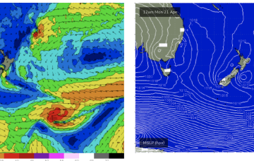
freeride76
Monday, 21 April 2025
We’ve got a more subdued synoptic outlook this week with weak high pressure currently in the Tasman and a complex troughy area of low pressure situated off the Southern NSW/Gippsland coast. That trough moves NE, backed by a large high pressure centre currently in the Bight. We’ll see the trough bring onshore winds and swell as it moves up the NSW Coast through the first half of this week.
/reports/forecaster-notes/sydney-hunter-illawarra/2025/04/18/large-clean-easing-surf-weekend-another
thermalben
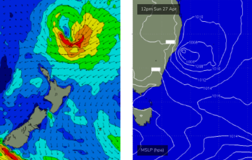
Friday, 18 April 2025
The large mid-latitude low in the central Tasman Sea - responsible for today’s very large surf - is slowly rotating clockwise, and by this evening won’t actually have a fetch aimed within our swell window.