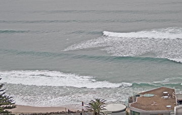
More fronts maintain a synoptic offshore flow for the week and we’ve got plenty of S swell to last the week, albeit at reduced sizes compared to the weekend.
Primary tabs
/reports/forecaster-notes/sydney-hunter-illawarra/2022/06/13/long-tail-quality-s-swell-week-mostly-0
freeride76
Monday, 13 June 2022
/reports/forecaster-notes/sydney-hunter-illawarra/2022/06/13/long-tail-quality-s-swell-week-mostly
freeride76
Monday, 13 June 2022
More fronts maintain a synoptic offshore flow for the week and we’ve got plenty of S swell to last the week, albeit at reduced sizes compared to the weekend.
/reports/forecaster-notes/sydney-hunter-illawarra/2022/06/10/solid-surf-and-offshore-winds-all
freeride76
Friday, 10 June 2022
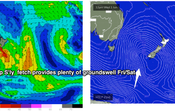
Current ASCAT (satellite wind speed) passes show gales to severe gales extending down to 55S with a tighter core of storm force winds just emerging from behind Tasmania as it tracks NE into the Tasman Sea. The synoptic flow from the fronts and Southern Gyre remains W to W/SW and that will continue all weekend with plenty of wind chill to boot.
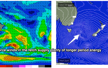
/reports/forecaster-notes/sydney-hunter-illawarra/2022/06/08/multiple-large-s-swell-pulses-incoming
freeride76
Wednesday, 8 June 2022
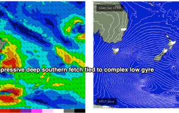
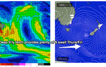
Strong high pressure support from a 1033hPa elongated high in the Bight is providing tight pressure gradients for the multiple fronts spinning off the gyre. That will lead to numerous over-lapping S’ly pulses over the coming week with a general step-ladder effect expected at least through to Mon. A general offshore flow will accompany these pulses as the fronts drive W’ly biased winds across the temperate to sub-tropical East Coast.

/reports/forecaster-notes/sydney-hunter-illawarra/2022/06/06/welcome-winter-part-2-step-ladder-s
freeride76
Monday, 6 June 2022
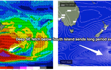
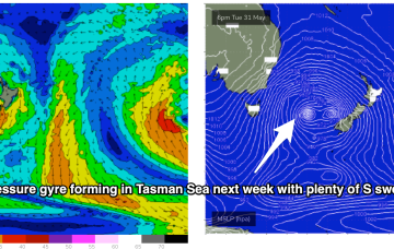
A strong node of the Long Wave Trough is steering fronts into the Tasman Sea while a negative phase of the SAM (Southern Annular Mode) is bringing the southern Ocean storm track into a more northerly latitude, closer to the Australian continent and Tasman Sea. Both those factors will drive a series of strong cold fronts this week, with a step-ladder effect likely on swell pulses as each subsequent front works on an already charged sea state.
/reports/forecaster-notes/sydney-hunter-illawarra/2022/06/03/negative-sam-amplify-the-southern
thermalben
Friday, 3 June 2022
Sunday’s NW quadrant wind trend will be related to an advancing frontal progression across the south-eastern corner of the country, associated with an amplifying Long Wave Trough.
/reports/forecaster-notes/sydney-hunter-illawarra/2022/06/01/welcome-winter-south-swells-and-westerly
freeride76
Wednesday, 1 June 2022
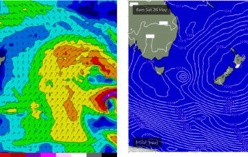
Brisk westerly winds and a complex low pressure gyre in the Tasman Sea, with multiple cold fronts and a deep S’ly fetch of gales extending down to 55S have ushered in the first day of Winter.
/reports/forecaster-notes/sydney-hunter-illawarra/2022/05/30/winter-wlies-ahead-strong-s-swell-the
freeride76
Monday, 30 May 2022
Another dynamic week ahead but a bit more straightforwards in the sense that all the incoming swell will be from the S - once the current E swell pulse peters out through tomorrow.
/reports/forecaster-notes/sydney-hunter-illawarra/2022/05/27/swells-all-over-the-compass-offshore
freeride76
Friday, 27 May 2022
Right on cue, as head into the first week of winter, a nice cold outbreak and blast of W’ly winds with accompanying S’ly swells is headed our way.
/reports/forecaster-notes/sydney-hunter-illawarra/2022/05/25/clean-conditions-combination-swells-nice
freeride76
Wednesday, 25 May 2022
Synoptic pattern still has a ground-hog day feel to it, with a large, slow moving high inching it’s way across the Tasman and a coastal trough lying parallel to almost the entire East Coast. Change is on the way though.