An active week of waves ahead

Victorian Surf Forecast by Ben Matson (issued Friday April 19th)
Features of the Forecast (tl;dr)
- Average waves this weekend with easing swells and abating winds
- Good surf most coasts Mon and maybe Tues with new, building swells and favourable winds
- Tricky winds rest of the week but with solid swells Wed, Thurs and esp Fri
Recap
Thursday offered good clean waves west of Melbourne up until the early afternoon, with light W/NW winds and clean 3-4ft sets before onshore winds ruined things later in the day. East of Melbourne was bigger but wind affected. Today has seen poor surf everywhere with building swells and fresh southerly winds.
(Please note: FC Notes will be variable in delivery this week as Craig is on paternity leave and Steve is covering Margs)
This weekend (Apr 20 - 21)
No major change to the weekend outlook.
Easing onshore winds will become light to moderate by Saturday and variable on Sunday but we really need a stiff synoptic offshore for a few hours, to iron out the wobbles. This isn’t like so expect lumpy leftovers for the most part.
Today’s size will slowly trend down through Saturday, initially some leftover 4ft sets west of Melbourne that’ll offer rideable but hardly epic options. East of Melbourne will probably see poor conditions everywhere on Saturday, too much onshore for the open beaches and not enough size for Western Port.
Although winds will likely become ‘variable’ on Sunday, we also need to remember that this means ‘from any direction’, which includes onshores - so keep your expectations low for the second half of the weekend. Size will ease further from 2-3ft to 2ft in Torquay with bigger but slightly more workable options at the open beaches east of Melbourne. But to be honest, only if you’re desperate.
Next week (April 22 onwards)
We've got plenty of surf lining up for next week though we have a few days of tricky winds to contend with.
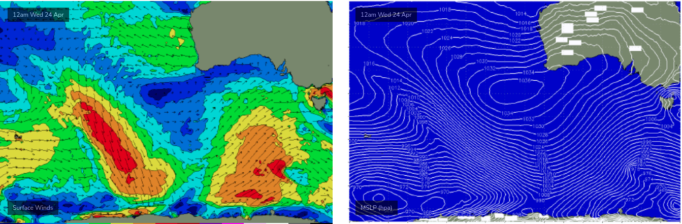
First of all, a strong frontal sequence through the Southern Ocean right now will generate a sequence of new long period swells for Monday and Tuesday, before a better long period SW swell then arrives very late Tuesday and peaks Wednesday - generated by a polar low intensifying south of WA on Sunday.
Finally, the best swell in this next pattern will arrive on Friday, generated by an intensifying polar low south of WA on Tuesday (see below) that will project nicely to the NE through our S/SW swell window into Wednesday, with the swell arriving overnight Thursday and showing best through Friday.
The fly in the ointment this week is a small cut-off low that’s expected to shear off the frontal boundary early in the week and push into the SA coast, however the models are divergent on how it will evolve past Tuesday - the US solution has it tracking quickly through Bass Strait (and bringing storm force onshore winds) whilst the European solution has it moving more slowly, with a different alignment.
Regardless, there are plenty of waves in store and as a minimum we should see clean conditions on Monday with fun building surf into the 2-3ft range west of Melbourne, bigger to the east near 3-5ft, and clean with light N’ly winds (note: confidence is low on size and timing from this swell, thanks to the unexpected unavailability of our model data today - I'll update over the weekend as new data comes to hand).
Tuesday should maintain Monday's pattern but I’m not totally confident on local winds right now so we’ll need to reassess on Monday.
The outlook for the rest of the week is also unclear - mainly due to local winds - but I feel that the Wednesday and especially Friday swells have much more size potential, probably somewhere around the 5-6ft+ across the Surf Coast. There's a very good chance that at least one of these days will have good winds for the Surf Coast, but it's not presently clear when that will be.
Let’s take a closer look on Monday. Have a great weekend!
Comments
Cheers BM - looks like you and Steveo have held the fort with aplomb this week in Craigos absence! Hope the Manly beachies turned it on to metaphorically "wet the head" of the newest arrival in the Brokensha household!
thanks mate :)
“Forecast graph data for the next few days is currently incorrect owing to a multi-day NOAA data outage earlier this week.”
This could halve the crowds next time it’s 6 ft + and offshore.
.