Workable waves to the east

Victorian Forecast by Craig Brokensha (issued Wednesday May 1st)
Best Days: Today selected spots, tomorrow morning selected spots, Friday morning to the east, Monday and Tuesday to the east
Features of the Forecast (tl;dr)
- Slight drop in swell tomorrow with light to moderate E/SE tending fresh SE winds
- Moderate sized, mid-period S/SW swell for late tomorrow but more so Fri AM, easing into the PM and into the weekend
- E-E/NE tending NE winds Fri ahead of strong SE sea breezes
- Small SE windswell Fri/Sat
- Moderate E/SE-E tending gusty SE winds Sat
- Inconsistent mix of W/SW-W groundswells building later Sun, peaking Mon
- Mod-fresh E/SE tending E/NE winds Mon, E/SE later
- Better W/SW groundswell for later Mon, peaking Tue Am
- NE-N/NE winds Tue
Recap
Poor surf yesterday with weak levels of mid-period S/SW swell and gusty onshore winds, better today across all locations with less wind on the Surf Coast and more favourable E/SE breezes to the east.
The swell is looking a bit stronger today as well with 3-4ft sets on the Surf Coast magnets, with 4-5ft surf persisting to the east. Winds should tend light E/NE and hold into the early afternoon ahead of sea breezes, providing decent waves for the keen until mid-afternoon.
This week and next (Apr 2 - 10)
The current mid-period swell energy is due to ease back into tomorrow morning though not likely dropping below 3ft on the Surf Coast and 4ft+ to the east. Winds don’t look to become as favourable as today, with a light to moderate E/SE breeze favouring selected spots during the morning before freshening from the SE into the afternoon.
Later in the day, but more so Friday morning, our new pulse of reinforcing S/SW swell is due, generated by off-axis but healthy strong to gale-force W/NW tending W winds moving along the polar shelf, south of the country yesterday.
This should boost the Surf Coast to 3ft+ with 4ft+ sets to the east, easing into the afternoon and then down from 2-3ft and 4ft respectively Saturday morning.
Winds on Friday look better, swinging E-E/NE through the morning and even possibly NE midday before strong SE winds kick in, with Saturday looking less favourable thanks to E/SE-E winds.
The SE windswell expected from the strong afternoon and evening SE winds looks a bit smaller now, with 2ft of weak swell now only expected from that source.
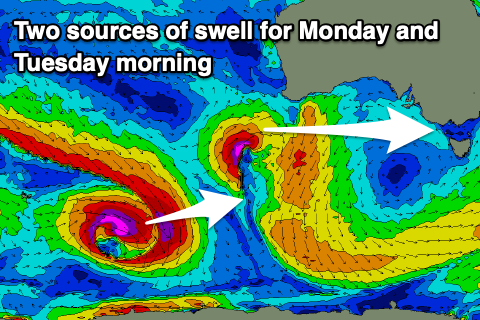
Moving into later Sunday but more so Monday, and some flukey, inconsistent groundswell energy is due from both the W and W/SW. The most reliable increase which is expected on Monday has been generated by a very distant frontal progression that formed south of South Africa on the weekend.
This isn’t due to offer much over 2ft to possibly 3ft on the Surf Coast and 3-4ft+ to the east Monday. Also in the mix looks to be a small W’ly swell from a tight low forming off WA over the coming days, but this looks poorly aligned for our region.
There’s also expected to be some better groundswell from a strong but short-lived polar low firing up just east of the Heard Island region tomorrow. Again the size looks as above, with it likely peaking Tuesday morning.
Local winds look less than ideal but workable, with Sunday seeing moderate, morning E/SE breezes, with fresher E/SE tending E/NE winds on the cards for Monday.
At this stage Tuesday looks the most reliable with NE-N/NE winds holding most of the day.
Longer term, the Southern Ocean becomes quite disjointed in regards to swell generating systems, but we’ll have a closer look at this Friday.
Comments
I guess u can kiss goodbye any sand build up on the SC..
Spring like.
2nd month of Autumn. 3rd or 4th year of La Nina; i've lost count.