Winteresque pattern ahead

South Arm Surf Forecast by Ben Matson (issued Friday April 19th)
Features of the Forecast (tl;dr)
- Small easing surf over the weekend
- Small clean surf early Mon
- Windy conditions developing mid-week onwards
- Stronger surf expected Wed/Thurs and especially Fri, but likely cold and blustery
Recap
Easing swells and onshore winds have maintained average conditions throughout the South Arm.
(Please note: FC Notes will be variable in delivery this week as Craig is on paternity leave and Steve is covering Margs)
This weekend (Apr 20 - 21)
No new groundswell is due over the weekend so options will be limited to exposed beaches on Saturday, before wave heights become too small throughout Sunday. Early Saturday may offer some 2-3ft sets at exposed South Arm beaches but it’ll ease to 2ft by the afternoon and then from 1-2ft down to 1ft on Sunday.
A fresh westerly flow just south of the state looks like it won’t have a great deal of influence through Storm Bay, so conditions should be clean for the most part with light variable winds in the mornings, and weak afternoon sea breezes.
Next week (April 22 onwards)
We've got plenty of surf lining up for next week though we have a few days of tricky winds to contend with.
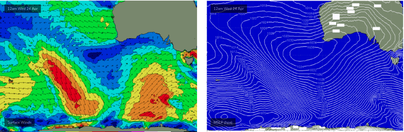
First of all, a strong frontal sequence through the Southern Ocean right now will generate a sequence of new long period swells for Monday and Tuesday, before a better long period SW swell then arrives very late Tuesday and peaks Wednesday - generated by a polar low intensifying south of WA on Sunday.
Monday should see early small surf across the open beaches with 1-2ft+ sets on offer, before freshening W/NW winds become gusty late in the day and into Tuesday morning (note: confidence is low on size and timing from this swell, thanks to the unexpected unavailability of our model data today - I'll update over the weekend as new data comes to hand).
Wednesday thru’ Friday is uncertain at the moment, mainly because the models are not properly resolving how a cut-off low in the Bight will behave. Regardless, strong fronts to our south will push up plenty of swell and it’s likely they’ll also impact the coast with strong to gale force winds from the SW quadrant.
The last swell in this next pattern will arrive late Thursday and peak into Friday morning, generated by an intensifying polar low south of WA on Tuesday (see below) that will project nicely to the NE through the South Arm’s short to mid-range swell window on Wednesday.
We still need a few days to iron out the local wind forecast though… it could end up being a day of small waves on the points but that’s not yet clear.
Let’s take a closer look on Monday. Have a great weekend!
Comments
Cheers for the update Ben. Not much to get excited about this weekend anyway. Hopefully next week's potential comes to fruition. And congrats to Craig on the new grom!
Ben
A mate rang me from his boat ( close 2 a dingy ) on Port Phillip Bay .
He has half a bucket of squid on board and is having Calamari 4 dinner .
That might B a Winteresque , sign. !
It's making me feel more hungry , 2 !