Poor weekend, large into early next week
Western Australian Forecast by Craig Brokensha (issued Friday December 13th)
Best Days: Keen surfers Friday, beaches Saturday morning, keen surfers Tuesday and Wednesday mornings
Features of the Forecast (tl;dr)
- Small mid-period W/SW swell tomorrow with early variable tending W/SW-SW winds
- Strengthening W/SW winds Sun with some building windswell
- Large W/SW-SW groundswell Mon with strong but easing SW tending S/SW winds, S/SE later in the South West (possible S/SE winds at dawn in the north)
- Easing swell Tue with gusty E winds ahead of later sea breezes
- Smaller Wed with early S/SE tending strong S-S/SW winds
- Large W/SW groundswell building next Thu with strong S/SE winds, easing Fri with gusty SE tending strong S winds.
Recap
A new pulse of mid-period SW swell filled in Wednesday afternoon before easing yesterday from 4ft+ or so in the South West with mostly decent conditions, small to tiny to the north.
Today is smaller and weaker with a few leftover waves in the South West.
This weekend and next week (Dec 14 - 20)
The coming weekend will be poor with a small mid-period W/SW swell tomorrow not expected to offer anything special as early variable winds increase from the W/SW-SW through the day. Stronger W/SW winds are then due Sunday as the remnants of a strong low to our south-west pushes through.
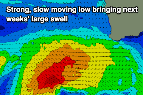
Now this low which will spawn off a strong frontal progression that’s currently moving east, south of the Indian Ocean is due to stall slightly on the weekend while generating W/SW gales through our western and south-western swell windows.
This stalling nature will see a large, consistent mix of W/SW and SW swell energy filling in Monday and likely coming in around the 12ft range across exposed breaks with 3-4ft surf in Mandurah and 3ft sets across Perth.
Winds still look average Monday for the South West and fresh to strong from the SW, easing through the day and tending S/SW, then S/SE on dark. Perth and Mandurah look 50/50 on whether they’ll see morning S/SE winds, with strong S/SW sea breezes due into the afternoon.

Tuesday is the pick of it as winds quickly swing around to a fresh E’ly, cleaning up the easing swell that should still be 8-10ft in the South West, 3ft Mandurah and 2-3ft Perth. Sea breezes look relatively weak and forming later before winds go back S/SE later.
Wednesday is a touch dicey now as the swell continues to ease and early S/SE winds tend strong S-S/SW shortly after dawn in the South West, better and E/NE to the north with easing surf from 2ft or so.
There won’t be much down time between swells with the next increase due Thursday, produced by another strong low moving in behind the current activity.
This looks to generate a small, tight fetch of gale to severe-gales with a broader fetch of strong to gale-force winds projected towards us, producing another moderate to large sized swell that should reach at least 8ft in the South West into the afternoon, 2-3ft Mandurah and 2ft Perth, easing from a similar size Friday morning.
S/SE winds look to create a few issues Thursday with better SE winds likely Friday. More on this Monday. Have a great weekend!

