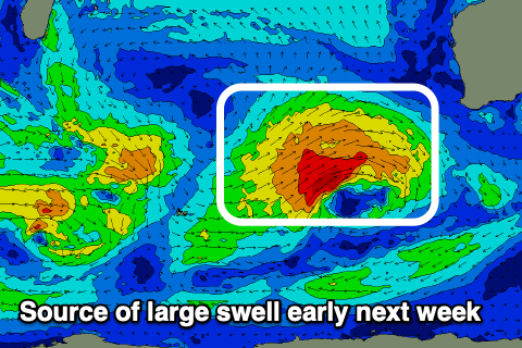
Another large swell early next week
Western Australian Forecast by Craig Brokensha (issued Wednesday December 11th)
Best Days: Perth and Mandurah Monday morning, Tuesday
Features of the Forecast (tl;dr)
- Small, reinforcing mid-period SW swell easing tomorrow with mod-fresh S/SE winds ahead of strong S/SW sea breezes
- Fading swell Fri with E/SE winds, tending onshore
- Increasing S/SW-SW tending W/SW winds Sat with small to tiny surf
- Stronger W/SW tending SW winds Sun with a local, building windswell
- Large SW groundswell Mon with S/SE-SE winds to the north, S/SW in the South West
- Easing swell Tue with fresh E-E/NE tending NW winds
- Smaller Wed with winds unsure
Recap
Wednesday’s swell didn’t quite reach the peak in expected size into the afternoon/evening, and this resulted in less size than expected across all regions yesterday morning as it eased.
There were still solid 8ft sets in the mix across the South West yesterday morning, 3ft in Mandurah and 2ft across Perth with winds remaining favourable across all locations through the afternoon.
Today is smaller and weaker with leftover 4ft waves in the South West, 1-2ft Mandurah and 1-1.5ft Perth.
This week and weekend (Dec 12 - 15)
A reinforcing pulse of mid-period swell is due tomorrow, but this only looks to come in at 4ft+ across the South West magnets in the morning, easing through the day. Perth and Mandurah will be tiny and winds look less than ideal, fresh from the S/SE before shifting S/SW-SW through the afternoon.
Friday looks cleaner but small and fading with weaker E/SE winds in the South West, variable offshore to the north before shifting onshore.
This onshore change will be linked to a small low moving in from the west, across us and with this overnight onshore winds are due to ease into Saturday morning. They look to linger out of the SW in the South West with S/SW winds to the north, swinging W/SW and freshening across all locations.

No new swell is due, while Sunday will see stronger W/SW tending SW winds as a cold front attached to a strong frontal progression clips us.
Now, this progression will begin south of South Africa today but really reach strength while traversing the Southern Ocean generating fetches of gale to severe-gale W/SW winds.
The movement of the storm is a little too quick and ahead of itself, and this will limit the size potential a touch, but the final stages to our south-west this Friday and Saturday will still produce some large groundswell regardless.
The swell is due to arrive overnight Sunday and peak Monday with large 10ft+ surf due in the South West, 3-4ft in Mandurah and 3ft across Perth on the sets. Winds will improve and shift S/SE-SE across metro regions Monday morning, lingering from the S/SW in the South West, with Tuesday seeing great offshore E-E/NE winds as the swell slowly eases from 8ft and 2-3ft respectively.
A trough may bring a S/SW change Wednesday as the swell eases further but we’ll look at this in more detail on Friday along with some decent sized, reinforcing swell late week.

