Mixed weekend, XL next week
Western Australian Forecast by Craig Brokensha (issued Friday October 11th)
Best Days: Today, Sunday morning, Tuesday afternoon in the South West, all day to the north, Wednesday morning
Features of the Forecast (tl;dr)
- Easing surf tomorrow with gusty S-S/SW winds
- Moderate + sized reinforcing SW groundswell Sun with E-E/NE tending W winds
- Smaller Mon with strengthening W/NW winds, variable early to the north
- XL, long-period W/SW groundswell showing later Mon, peaking Tue with mod-fresh but easing SW winds in the South West, likely S/SE for a period in the morning to the north
- Large easing swell Wed with E/NE tending NW winds
Recap
The surf pumped across all locations yesterday with a secondary pulse of large, reinforcing groundswell under all day offshore winds in metro locations, while a sea breeze came to spoil the party in the South West around early afternoon.
Today there’s still 8ft surf in the South West, 3ft waves across Mandurah and 2-3ft sets in Perth with great conditions again. Winds are now starting to go a little north adding bumps.

Solid yesterday
This weekend and next week (Oct 12 - 18)
The current swell is expected to ease back more in size tomorrow and a trough will bring unfavourable S-S/SW winds, swinging back offshore on Sunday from the E tending E/NE.
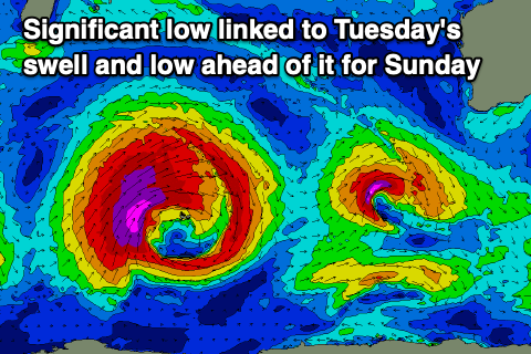
Swell wise a reinforcing pulse of SW groundswell is due Sunday, generated by a tight and intense low that’s currently west-southwest of us.
This should boost the South West back to the 6ft range on the sets with 2ft sets in Mandurah, 1-2ft across Perth.
Make the most of this clean, fun morning of waves as winds will shift W’ly into the afternoon and then strengthen from the W/NW on Monday as the swell bottoms out. Perth and Mandurah should see early variable winds but no size.
We then look at our XL groundswell due into Tuesday. The severe low linked to this swell has already formed south-east of South Africa and is now moving east across the Heard Island region with a great fetch of storm-force SW winds being projected up through our western swell window.

We’ll see storm-force winds continuing through this evening before slowly weakening while projecting up a little higher towards us.
The low will break down west of us through Sunday/Monday and left in its wake will be one of the largest, strongest groundswells of the year.
An XL W/SW groundswell is expected, with the forerunners arriving Monday ahead of a peak on Tuesday to 15-20ft across the deepwater breaks in the South West, 4-5ft Mandurah and 4ft on the sets in Perth.
Winds are now looking better for Tuesday, but still onshore in the South West. A fresh but easing SW breeze is due while to the north we’re likely to see light S/SE morning winds ahead of weak sea breezes. Check back here Monday for confirmation on this.
Wednesday as the swell eases now looks excellent with an E/NE offshore across all locations and easing 10ft waves in the South West, 3-4ft across Mandurah and 2-3ft in Perth.
Thursday also looks clean and smaller but the models diverge on secondary frontal activity moving in from the west. More on this Monday. Have a great weekend!

