Mostly onshore winds with large surf
Western Australian Forecast by Craig Brokensha (issued Monday August 26th)
Best Days: Keen surfers Perth and Mandurah Wednesday morning, Sunday morning Perth and Mandurah, Monday morning all locations
Features of the Forecast (tl;dr)
- Large W/SW groundswell tomorrow with strong W/NW tending W/SW winds
- Large mid-period SW swell Wed AM, easing
- Fresh W/NW winds, strengthening from the NW Wed (moderate N/NE early Perth and Mandurah)
- Strong W/SW winds Thu with large, building surf again, easing Fri with strong W/SW winds
- Large SW groundswell building late Fri, peaking Sat
- Mod-fresh W/SW winds Sat
- Large mid-period S/SW swell Sun, with some stronger groundswell Mon
- Moderate SW winds Sun, likely S/SE early Perth and Mandurah
- E/NE tending NW winds Mon
Recap
The weekend saw a vigorous frontal system pushing up and across the state bringing very strong winds and a building, stormy swell that jumped in size sharply Saturday, easing a touch yesterday. Today we’ve got the groundswell component of the swell with strong onshore winds out of the NW.
This week and weekend (Aug 27 - Sep 1)
In short our possible windows of cleaner conditions for the coming week and weekend have unfortunately been shortened or closed completely with the strong frontal activity that’s been firing up more west of us now due to move more across us.
This will be thanks to a strong node of the Long Wave Trough (the drived of the activity) moving in from south-west of us, more towards the south-east of the country this week.

This will see the focus of frontal activity shifting a bit more east, but not east enough for us to be released by the grip of onshore winds.
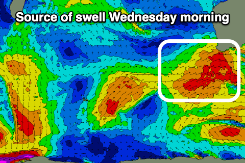
So looking at tomorrow and strong W/NW tending W/SW winds are due as a severe cold front clips us, bringing with it a fresh pulse of large W/SW groundswell tomorrow morning, while a trailing front looks to generate some large, mid-period SW energy for Wednesday.
Onshore winds are due to ease and shift more W/NW Wednesday morning (still fresh though) before strengthening from the NW.
Perth and Mandurah should see a period of early, moderate N/NE winds, tending N/NW during the day and freshening.
Size wise Perth looks to be 3ft with 4ft sets across Mandurah but options will be limited.
Into the end of the week, a developing cold outbreak to our east will bring those strengthening NW winds on Wednesday afternoon, with a strong W/SW change due into Thursday morning along with some large, localised building W/SW swell.
Fetches of SW gales to our south-west should then generate large levels of SW swell for later Friday and Saturday morning but with strong W/SW winds persisting on the former, moderate to fresh on the latter.

Weaker SW winds are likely on Sunday (likely S/SE early Perth and Mandurah) along with large levels of new mid-period S/SW swell followed by a stronger groundswell Monday.
These swells will be generated by the same system, that being a deep polar low forming west of the Heard Island region on Thursday, with a storm-force fetch due to then weaken and race ahead of itself, under us Saturday.
The system racing ahead of itself will generate the spike in size Sunday, with the groundswell arriving a day later on Monday.
Surf to the 10ft range is currently expected in the South West with 3ft sets across Mandurah, 2ft+ across Perth both Sunday and Monday, with winds shifting from E/NE to NW on Monday. We’ll have a closer look at this Wednesday.

