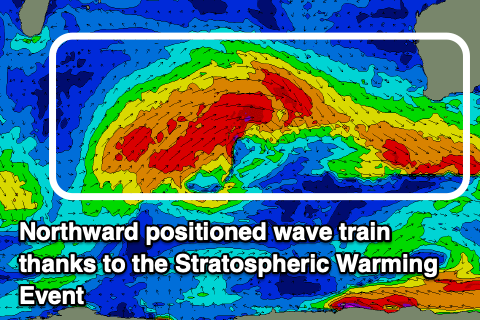
Stratospheric warming hits home
Western Australian Forecast by Craig Brokensha (issued Wednesday August 7th)
Best Days: Keen surfers Friday and Saturday mornings Perth and Mandurah
Features of the Forecast (tl;dr)
- Large, easing swell tomorrow with fresh W/NW winds (possible variable Perth early)
- Smaller Fri and Sat with strong N/NW winds (N/NE-NE early Perth and Mandurah)
- Large building W/SW groundswell Sun with strong NW tending W/NW winds, peaking Mon with strong W/NW winds
- Easing swell Tue with strong W/NW winds
Recap
There was a window of OK conditions and building swell across Perth yesterday morning, less so across Mandurah and onshore across Margaret River. A large W/SW groundswell filled in through the day, but this is being overtaken by some close-range swell today with strong onshore winds.
There have been periods of weaker onshore flow but all in all, it’s a write off across all locations.
This week and weekend (Aug 8 - 11)
It looks like we’re going to feel the full brunt of the stratospheric warming events in the upper atmosphere this period.
What this warming has done is lift the westerly storm track further north up to the mid-latitude and this is occurring primarily west of us.
In short we’re set to see a persistent stream of high-riding mid-latitude frontal systems bringing large levels of stormy swell with persistent onshore winds.
The wave train doesn’t look to let up at all for the coming fortnight, shifting further east as we go which means onshore winds for nearly the entire period, improving hopefully in a couple of weekends time.

Firstly, the current system will clear east overnight leading to a slow drop in swell tomorrow with gusty W/NW winds persisting across the South West and Mandurah, likely variable across Perth but only for a short period. Margs looks to ease from 10-12ft, 4ft Mandurah and 3-4ft Perth.
Friday will offer smaller surf with strengthening N/NW winds, N/NE early across Perth and Mandurah. Sets should still be 2-3ft but dropping.
Smaller surf but similar winds are due on Saturday with Perth and Mandurah doing OK, while Sunday looks poor with strong NW tending W/NW winds as the remnants of a significant cold outbreaks moves in from the west.
The initial stages of this cold outbreak should see fetches of gale to severe-gale W/SW winds projected towards us, generating a large W’ly groundswell for Sunday afternoon, peaking Monday.
This swell will be spoilt by strong W/NW winds Monday as the remnants continue to move through, similar Tuesday as the swell eases.
Further frontal activity will bring weaker but still large surf and onshore winds most of next week, possibly letting up sometime the following weekend, but this is still a long shot. Keep checking back each update.

