Large to oversized swells with persistent north-west winds
Western Australian Forecast by Craig Brokensha (issued Monday August 5th)
Best Days: Keen surfers Perth and Mandurah tomorrow, Thursday morning Perth and Mandurah, early Friday for the keen Perth and Mandurah
Features of the Forecast (tl;dr)
- Large W/SW groundswell building Tue with strengthening N/NW tending NW winds (N/NE early Perth and Mandurah)
- Strong W/NW winds Wed with a renewal of building large W/SW swell
- Larger W/SW swell Thu with mod-fresh W/NW winds, more variable to the north
- Easing swell Fri with strengthening NW winds, N/NE early Perth and Mandurah
- Smaller Sat with N/NW winds (N/NE early Perth and Mandurah)
- Building surf Sun with W winds
Recap
The swell hung in a little better than expected across the metro locations on the weekend with 2ft+ sets seen Saturday, still 2ft yesterday and with clean conditions.
The Margaret River region cleaned up into Saturday with 4-6ft surf, smaller and to 4ft or so yesterday.
This morning an approaching front has brought poor winds and conditions to the South West, deteriorating across Mandurah and still doable around Perth early with 2ft sets.
This week and weekend (Aug 6 - 11)
The week and period ahead will be full of swell but poor winds and conditions as we fall foul of a strong node of the Long Wave Trough sitting across the Indian Ocean.
This will bring with it a stream of high riding frontal systems and with strength. Unfortunately they’ll be on the downwards slide across us, bringing persistent winds from the north-western quadrant.
Perth and Mandurah will be the best bets in between fronts when winds go more variable and locally offshore for periods.
Coming back to tomorrow and we’ve got a large W/SW groundswell due, with it expected to build into the afternoon and peak later to 10-12ft in the South West, 3-4ft in Mandurah and 3ft across Perth.
The source was a strong low spawning off South Africa, and the remnants will move in and across us at the same tomorrow, bringing strong N/NW tending NW winds. Perth and Mandurah should see fresh N/NE winds early with small surf. Not ideal.

Moving into Wednesday, strong W/NW winds will create poor conditions everywhere along with a large mix of building W/SW swells.
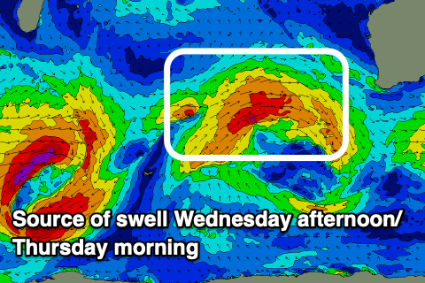
This will be thanks to mid-latitude frontal activity approaching from the west over the coming days, generating fetches of strong to gale-force W’ly winds.
Building surf to 12ft+ is due across the South West later Wednesday, easing from a similar size Thursday morning with 4-5ft sets across Mandurah, 3-4ft in Perth.
Thursday morning looks like one of those windows of lighter winds across the metro regions, with variable tending light offshore breezes due, with a bit of lump in the mix. Winds will ease in the South West but still be moderate to fresh W’ly.
Strengthening NW winds are again due into Friday but with easing surf, N/NE-NE in the morning across Perth and Mandurah.
The weekend looks smaller again and with similar winds to Friday, shifting more W’ly from Sunday as the next pulse of swell arrives.
It’ll be another episode of large W’ly energy though likely not to the size of this week and with persistent onshore winds across the South West.

