Good surf on the weekend, with options next week
Western Australian Surf Forecast by Craig Brokensha (issued Friday March 1st)
Best Days: Protected spots this afternoon, tomorrow, Sunday, Wednesday morning, Thursday morning
Features of the Forecast (tl;dr)
- Easing swell tomorrow with a mod-large, reinforcing pulse of S/SW swell for later in the day, easing Sun
- Strong E/SE winds tomorrow, easing ahead of late sea breezes in the South West
- Funky winds Sun, E tending N in the South West, strong E/NE to the north (possibly SW for a brief period in the AM)
- S/SW winds Mon in the South West, NW tending SW to the north
- Moderate-large mix of SW swells for Wed, peaking through the day with gusty E/SE-SE winds ahead of sea breezes
- Easing swell Thu with E tending S/SW winds
Recap
A good increase in mid-period SW swell yesterday morning with sets to 5-6ft across the South West under favourable winds, 1-2ft to the north but slow.
A larger pulse of S/SW groundswell kicked late in the day but has peaked this morning with windy but strong 8ft sets in the South West, 2-3ft across Mandurah and 2ft on the sets in Perth.

Chunky, windy surf this afternoon
This weekend and next week (Mar 2 - 8)
Looking at the weekend ahead, the current swell is expected to ease back into tomorrow morning, though later in the day a good pulse of reinforcing S/SW energy is due.
This has been generated by a healthy, broad frontal system firing up on the tail of the polar low linked to this morning's groundswell. Tomorrow morning is likely to be in the 4-6ft range, kicking a little later to 5-6ft+, then easing from 4-5ft+ Sunday morning. To the north, easing sets from 1-2ft are due across Perth and Mandurah tomorrow, similar Sunday morning.
Winds should swing E/SE tomorrow morning, strong early before easing, with no sea breezes to the north, possibly moving in across the South West.
Sunday is funky with a surface trough possibly bringing a shallow SW change to metro locations, but more than likely offshore from the E/NE and strong, easing through the afternoon. The trough proper is due to move in Monday swinging winds onshore from the NW across metro locations and SW to the south.

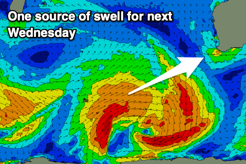
As touched on last update, a new mix of SW swells are due to start building Tuesday afternoon but more so through Wednesday, generated by back to back storms firing up around the Heard Island region from today.
An initial polar front should generate a fetch of strong to gale-force SW winds before dissipating, quickly piggy-backed by a weaker but closer moving frontal system. This will generate a moderate + sized mix of swells for Wednesday, peaking through the day to the 6ft range in the South West, 2ft across Mandurah and 1-2ft to the north.
Local winds are due to shift S/SE following Monday's change into Tuesday with Wednesday offering E/SE-SE winds with the peak of the swell.
Following on from this, we're looking at a persistent run of moderate sized swells with winds out of the south-eastern quadrant but we'll review this Monday. Have a great weekend!

